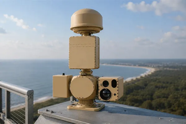
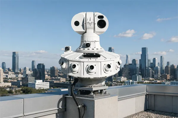
Ports are not single-domain surveillance sites. A security team may need to detect a small craft approaching a breakwater, a service boat entering a restricted berth, a person moving between container stacks and a low-flying drone crossing above cranes—sometimes within the same operational window.
These targets do not create the same radar return, move through the same geometry or require the same verification method. A surface radar optimized for vessels does not automatically provide reliable three-dimensional drone surveillance, while a low-altitude radar may not be the most efficient sensor for persistent wide-area monitoring of boats and shoreline movement.
The practical solution is a layered port surveillance radar system that assigns each sensor a defined task, combines tracks and video in one platform, and tests the complete workflow against realistic site conditions. This guide explains how to design and evaluate that architecture without treating maximum range as the only procurement criterion.
How to Detect Small Boats and Low-Flying Drones in Cluttered Port Environments
1. Why Ports Require Dual-Domain Surveillance
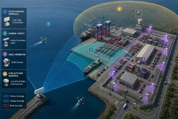
Port security operates across four connected spaces: open water, harbor and berth areas, land-side yards and perimeter zones, and the low-altitude airspace above the facility. Each space produces a different target and clutter problem.
| Operational zone |
Representative targets |
Dominant difficulty |
Primary surveillance objective |
| Outer maritime approach |
Small craft, workboats, approaching vessels |
Sea clutter, weather, long range, low target height |
Early detection and stable vessel tracking |
| Harbor and berths |
Service boats, unauthorized craft, floating objects |
Wakes, moored vessels, breakwaters, cranes |
Track continuity in dense and obstructed water areas |
| Yard and perimeter |
People, vehicles, gate and fence movement |
Container stacks, machinery, road traffic |
Zone-based intrusion detection and camera verification |
| Low-altitude airspace |
Multirotor UAVs, fixed-wing UAVs, birds |
Ground clutter, cranes, buildings, target fluctuation |
Three-dimensional tracking, classification and timely cueing |
The system therefore needs more than one sensor category. The goal is not to collect the largest number of devices; it is to remove coverage gaps between water, land and air while avoiding duplicated alarms and unclear operator responsibility.
2. Why the Port Environment Is Difficult for Radar and Cameras
A port combines dynamic natural clutter with dense man-made structures. The environment changes by sector and by time of day, so tuning that works in an open coastal direction may fail when the same radar looks toward a quay, container crane or road.
- Sea-surface clutter changes with wind, wave direction, sea state, rain, spray and grazing angle.
- Large steel vessels, cranes, fences, tanks and container stacks create strong reflections, shadow zones and multipath effects.
- Moving machinery, road traffic, rotating equipment and wakes can compete with weak targets or produce nuisance tracks.
- Small boats may have low, unstable radar returns; slow drones may overlap with ground clutter and bird activity.
- Fog, haze, backlight and night conditions reduce visual range, while rain and atmospheric effects can reduce both radar and EO/IR performance in different ways.
For the radar-physics discussion, see Midradar’s guide to small boat detection in sea clutter. This page remains focused on the broader port-system architecture and does not repeat that analysis.
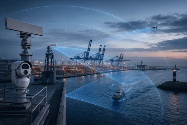
Figure 1. Illustrative port coverage layers. This is a planning concept, not a site-specific coverage prediction.
3. Surface Surveillance Radar and Low-Altitude Radar Perform Different Tasks
A useful procurement document should separate the water-surface and aerial requirements before selecting equipment. “Air, land and sea detection” in a product description does not by itself prove that one radar will deliver equal operational performance in all three domains.
| Comparison point |
Surface surveillance radar |
Low-altitude 3D radar |
| Primary target domain |
Vessels, small craft, vehicles and personnel close to the surface |
UAVs, birds and other low-flying targets requiring altitude information |
| Key output |
Range, azimuth, speed, heading and stable surface track |
Three-dimensional position, altitude, velocity and aerial track |
| Coverage geometry |
Long horizontal sectors; near-surface line of sight |
Azimuth plus sufficient elevation coverage and altitude ceiling |
| Important design factors |
Sea clutter, minimum velocity, shoreline masking, radar horizon |
RCS, altitude, micro-Doppler or other classification features, building and crane clutter |
| Typical operational role |
Wide-area maritime approach and shoreline monitoring |
Local or facility-wide low-altitude airspace awareness |
| Failure if misapplied |
A headline vessel range may not translate into drone coverage |
A drone-focused radar may leave inefficient or incomplete maritime sectors |
The architecture should therefore treat surface surveillance radar and low-altitude surveillance radar as complementary sensor layers. A common platform can combine their outputs, but the technical requirements should remain explicit.
4. Define the Complete Detection Chain
A port security requirement should not stop at “detect the target.” The operational chain has at least five stages, and a failure at any stage can prevent a useful alarm.
| Stage |
Operational meaning |
Acceptance question |
| Detection |
A target-like return is produced. |
At what range and under which target and clutter conditions? |
| Track initiation |
Repeated observations are associated into a track. |
How many scans and how much time are required? |
| Stable tracking |
Identity, position, speed, heading and altitude are maintained. |
What track loss and reacquisition behavior are permitted? |
| Classification / verification |
The system assigns a class or cues EO/IR for human confirmation. |
Can operators distinguish a threat from birds, waves, traffic or authorized activity? |
| Alarm and response |
Rules convert the verified track into an operational event. |
Which zone, direction, route, speed or schedule triggers escalation? |
| Procurement principle Stable track, camera cueing and alarm delivery are normally more valuable than a single long-range plot. Require suppliers to state the tested range and criteria for each stage. |
5. Build a Layered Sensor Architecture
A layered architecture assigns one primary sensing task to each component and defines how the data is combined. A typical port configuration may include the following elements.
Outer maritime surveillance layer
A long-range surface surveillance radar covers approach channels, anchorage boundaries, breakwater approaches and selected offshore sectors. The requirement should identify the target class, route, sea conditions, minimum speed and track-continuity expectation—not only instrumented range.
Inner harbor and berth layer
A second surface-radar sector or a more local radar configuration may be needed where cranes, moored vessels, islands, piers or curved shorelines block the outer sensor. The inner layer should prioritize minimum range, resolution, slow-target behavior and continuity through crossing traffic.
Low-altitude airspace layer
A three-dimensional low-altitude radar monitors likely drone approach routes above water, logistics yards, fuel storage, control buildings and restricted berths. The design must consider elevation coverage, crane and building masking, target altitude, update rate and the ability to maintain tracks during maneuvering.
EO/IR verification layer
Visible and thermal cameras provide classification evidence that radar alone may not deliver. The camera specification must be evaluated against the required target size, field of view, atmospheric conditions, stabilization, pan-tilt speed and the time available before the target reaches the protected zone.
Cooperative and supplementary data
AIS, ADS-B, RF detection and access-control data can add context, but they should not be treated as substitutes for independent sensing. Cooperative transmitters may be absent, disabled, incorrect or irrelevant to the target being investigated.
Unified command platform
The platform should display air, water and ground tracks on the same geospatial reference, correlate duplicate reports, control EO/IR cueing, apply alarm rules, record evidence and expose a clear health status for every connected sensor.
Where the project includes an authorized counter-UAV workflow, use the integrated counter-UAV solution as the adjacent system reference. Detection, identification and response functions should remain separately defined in the commercial scope.
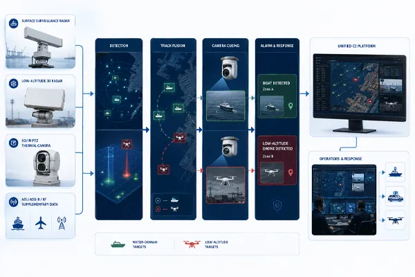
Figure 2. Layered port surveillance architecture from sensors to operational response.
How to Detect Small Boats and Low-Flying Drones in Cluttered Port Environments
6. Design Coverage by Operational Zone, Not by Product Range
A coverage plan should begin with the protected area and target routes. Sensor quantity and installation positions are outputs of that study, not assumptions fixed by the product datasheet.
| Zone |
Area to protect |
Key design requirement |
Typical blind-zone risk |
| A — Outer approach |
Approach channels, anchorage boundary, offshore restricted area |
Long-range surface tracking, radar horizon, sea-state performance |
Large vessel masking, curvature, offshore structures |
| B — Harbor / berth |
Berths, basin, service channels, breakwater openings |
Minimum range, slow targets, dense track separation |
Moored vessels, cranes, wakes, multipath |
| C — Yard / perimeter |
Container yard, gates, fuel areas, warehouses |
Ground intrusion zones and video verification |
Container stacks, roads, machinery, temporary structures |
| D — Low-altitude airspace |
Waterfront, cranes, control buildings, restricted cargo areas |
3D UAV tracking, elevation coverage, fast cueing |
Crane shadow, roofs, authorized drones, birds |
The site survey should record:
- radar and camera coordinates, mounting heights and structural limits;
- terrain, shoreline, pier, vessel, crane and container-stack masking;
- near-field blind zones and required overlap between sensors;
- target height and route at multiple distances;
- power, fibre, network, grounding, lightning, corrosion and maintenance access;
- temporary port configurations, including mobile cranes, stacked containers and visiting large vessels;
- the permitted response time from first operational track to visual confirmation.
For land-side and waterfront boundaries, the perimeter protection and border and coastal surveillance pages provide adjacent application context, but this article should remain focused on port-specific multi-domain integration.
7. Radar-to-Camera Cueing Must Be Engineered, Not Assumed
A statement that a radar “supports PTZ linkage” may mean only that coordinates can be exported. Reliable automatic cueing requires a complete data and calibration chain.
| Integration item |
What must be defined |
| Coordinate reference |
Latitude/longitude, local grid, altitude reference and map projection must be consistent. |
| Time synchronization |
Radar, camera, server and platform timestamps must be aligned closely enough for moving-target prediction. |
| Track identity |
The platform must preserve track IDs and manage duplicate or merged tracks across sensors. |
| Latency and prediction |
The cueing calculation should account for sensor update rate, network delay, PTZ acceleration and target motion. |
| Boresight calibration |
Radar coordinates, camera optical axis, mast orientation and terrain model must be calibrated at the site. |
| Field of view and handover |
The camera should arrive with sufficient field of view to acquire the target before zooming or handing over between units. |
| Acceptance test |
Cueing error, acquisition time, target retention and failure recovery should be measured, not described qualitatively. |
The system proposal should identify whether the supplier is delivering an API, a camera driver, a configured workflow or a fully commissioned radar-vision fusion system. These are not equivalent commercial scopes.
8. Manage False Alarms by Domain and Zone
One global sensitivity setting is rarely suitable for a port. False-alarm control should combine sensor processing with location-aware rules and operator workflow.
| Domain |
Common nuisance source |
Control approach |
| Water surface |
Waves, rain cells, wakes, buoys, floating debris |
Adaptive clutter maps, speed / route filters, zone-specific thresholds, multi-scan confirmation |
| Harbor infrastructure |
Cranes, rotating machinery, moving gantries, large-vessel reflections |
Exclusion masks, structural maps, track-quality rules and periodic retuning |
| Land perimeter |
Road traffic, authorized workers, vegetation, loading equipment |
Virtual fences, schedules, direction rules and access-control context |
| Low-altitude airspace |
Birds, authorized drones, ground reflections, weather |
3D track features, classification support, EO/IR verification and authorized-flight lists |
A low nuisance-alarm rate should not be achieved by raising thresholds until weak targets disappear. Acceptance testing should measure both missed detections and nuisance alarms during representative port operations.
How to Detect Small Boats and Low-Flying Drones in Cluttered Port Environments
9. Example Midradar Configuration Logic
| Configuration note The following table is a product-mapping example, not a final site design or performance guarantee. Final selection requires the target definition, coverage drawing, site survey, integration scope and acceptance criteria. |
| Operational need |
Candidate Midradar element |
Primary role |
Buyer must verify |
| Wide maritime approach / coastal sector |
MR-RDG50K surface surveillance radar |
Long-range surface and shoreline surveillance layer |
Confirm permanent canonical product URL before publishing; validate target-specific range and sector geometry. |
| Harbor, berth or medium-range waterfront sector |
MR-RDG20K surface surveillance radar |
Surface vessels, small craft and land/water moving targets |
Review minimum range, obstruction map, slow-target conditions, overlap and camera placement. |
| Local low-altitude airspace around port assets |
Current approved low-altitude surveillance radar model (MR-RDV05K candidate; release-day verification required) |
3D detection and tracking of small UAVs and other low-altitude targets |
Do not publish or link a model until the English product page and approved specification are live. Validate target RCS, altitude, clutter and update requirements. |
| Visual verification and evidence |
MR-HTVC6511-2132 Long-Range Thermal Security Camera |
Day/night target confirmation, radar-linked cueing and PTZ tracking |
Confirm thermal and visible DRI requirements, lens selection, PTZ speed, stabilization, maritime corrosion protection, protocols and calibration scope. |
| Unified operational picture |
Radar-Vision Fusion / C2 platform |
Track display, cueing, alarm rules, evidence and device health |
Define APIs, licence model, cybersecurity, user roles, logging and third-party integration responsibility. |
10. Define the Integration and Cybersecurity Boundary
A port surveillance proposal should identify which party supplies the sensor network, servers, time source, video management, GIS, cybersecurity controls and interfaces to the existing command platform. Protocol compatibility is not the same as completed integration. The contract should state data ownership, user roles, authentication, encryption, logging, configuration backup, software-update responsibility and the procedure for recovering from a failed sensor or network link.
Require controlled interface documentation and an end-to-end demonstration using the proposed radar, EO/IR payload, command software and external platform. The test must verify coordinate conversion, timestamps, track identity, alarm mapping, video handover and operator acknowledgement under realistic latency and bandwidth conditions.
11. Use a Port-Specific Site Acceptance Test
Site acceptance should test the complete operational chain rather than isolated sensor power-on. Define representative boat, drone, vehicle and personnel scenarios; approach routes; sea state and weather records; detection and stable-tracking criteria; nuisance-alarm observation periods; camera cueing; event logging; failover; and operator workflow. Record raw tracks, video, timestamps, configuration files and exceptions so that the result is auditable.
Common Port Surveillance Design Mistakes
- Using one maximum-range figure for small boats, large vessels and drones without separate target definitions.
- Assuming a maritime radar automatically provides reliable altitude and classification data for low-flying UAVs.
- Placing all sensors on one mast without reviewing mutual masking, vibration, maintenance access and camera geometry.
- Ignoring temporary obstructions created by container stacks, cranes and large visiting vessels.
- Treating AIS, ADS-B or RF detection as a complete substitute for independent radar and EO/IR sensing.
- Accepting “PTZ linkage supported” without an integration, calibration and cueing test scope.
- Testing targets one at a time in quiet conditions while ignoring dense normal port operations.
- Comparing equipment price without servers, software, licences, civil works, commissioning and lifecycle support.
Conclusion
Detecting small boats and low-flying drones in a port is not a single-radar selection problem. It is a coverage, integration and operational-workflow problem across water, land and air.
A defensible design separates surface and aerial sensing tasks, uses EO/IR for visual verification, combines tracks in a unified platform, controls false alarms by zone and verifies the complete chain through a port-specific site acceptance test. The correct configuration depends on the target, site geometry, installation height, response time and integration boundary—not on the largest number printed in a datasheet.
Request a Port Coverage and Integration Review
Midradar can prepare a preliminary configuration basis for ports, container terminals, coastal facilities and offshore infrastructure. Provide:
- site map or coordinates and protected-area boundaries
- target types, sizes or RCS references and expected routes
- required warning time and response workflow
- existing radar, AIS, cameras, VMS, PSIM or VTS interfaces
- candidate sensor and camera installation points
- environmental, corrosion, power and network constraints
- acceptance-test expectations and project schedule
The output can be used to compare sensor quantities, coverage assumptions, integration scope and acceptance responsibilities on consistent terms. Contact Midradar for a project review.
FAQ
Can one radar detect both small boats and drones in a port?
Some radars can report targets in more than one domain, but one product should not be assumed to provide equal operational coverage for boats and low-flying drones. Buyers should verify the target-specific range, elevation coverage, altitude output, clutter conditions and tracking criteria for each domain.
Why is a separate low-altitude radar often required?
A low-altitude radar provides three-dimensional aerial tracking, including altitude and sufficient elevation coverage. These outputs are important for maintaining drone tracks and cueing cameras around cranes, buildings and other vertical obstructions.
Is AIS sufficient for detecting unauthorized boats?
No. AIS adds useful cooperative identity and voyage information, but it does not independently detect craft that are non-cooperative, unregistered, incorrectly reporting or too small to carry the required transmitter.
How should a port reduce false alarms from waves and birds?
Use domain-specific processing and zone rules, then verify targets through track behavior and EO/IR. The acceptance test should measure nuisance alarms and missed detections together so that sensitivity is not reduced simply to make the alarm count look better.
How many radar units does a port need?
The number depends on coastline shape, port structures, target routes, installation heights, redundancy and blind-zone tolerance. A site-specific coverage drawing is required before fixing sensor quantity.


 11:24
11:24