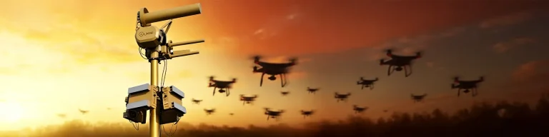
What Counts as “Detection Range” on a Spec Sheet?
Most ground surveillance radar pages lead with a single number, “up to 50 km,” without saying what that number is measuring. It matters, because range is not one fixed property of the radar. It is a function of the target’s radar cross-section (RCS), its height above the ground, its speed, and the angle at which it presents itself to the antenna.
A standing or walking adult has a small RCS. A vehicle has a much larger one, made mostly of flat metal panels that reflect energy efficiently back toward the antenna. A small boat sits on open water with little background clutter around it, which is why vessel detection often reaches the upper end of a radar’s rated range while personnel detection sits at the lower end of the same unit.
This is the most common misreading of a radar spec sheet: treating “maximum range” as a single guarantee that applies equally to every target type. It does not. A 25 km-rated system for vehicles will not detect a crawling person at 25 km; the two numbers belong to different target categories on the same datasheet.
MR-RDG Series: Ground Surveillance Radar Specs by Target Type
| Target Type |
Typical Detection Range (MR-RDG Series) |
Why Range Varies |
| Walking adult (personnel) |
2–15 km |
Small radar cross-section; range narrows further in tall grass, crops, or urban clutter |
| Vehicle |
5–25 km |
Larger metal surface returns a stronger signal at distance |
| Vessel / small boat |
5–50 km |
Open water has less background clutter than land terrain |
Across Midradar’s hệ thống radar line, including the RDG series, the operating envelope spans -40°C to +55°C, with IP66/IP67 ingress protection for outdoor, unattended installation.
Personnel Detection Range
MR-RDG series ground surveillance radar detects a walking adult at roughly 2–15 km. The lower end of that band is typical for vegetated or cluttered terrain, while the upper end applies to open, flat ground with a clear line of sight.
Vehicle Detection Range
Vehicle detection runs roughly 5–25 km. A loaded cargo truck and a motorcycle present very different radar cross-sections, so the practical range for a given vehicle sits somewhere inside that band rather than at the top end by default.
Vessel Detection Range
Vessel detection reaches the widest band, roughly 5–50 km, because open water carries far less background clutter than land. A small fishing boat riding low in the water still returns less signal than a larger hull, so the same radar can show a noticeably different range across a fleet of different boat sizes.
The series itself spans six models: MR-RDG03K, MR-RDG03-4R, MR-RDG06K, MR-RDG07K, MR-RDG20K, and MR-RDG50K. Midradar has not published a distance figure for each individual model against each target type; that level of detail comes through the project datasheet once a buyer specifies their target mix and mounting plan, rather than a single blended number covering all six units.
Most vendor product pages publish one headline “maximum range” figure for an entire ground radar line. Breaking it out by personnel, vehicle, and vessel, as shown in the table above, gives a procurement team a faster way to check whether a specific model actually covers their threat profile before requesting a quote.
Radar giám sát bề mặt G20
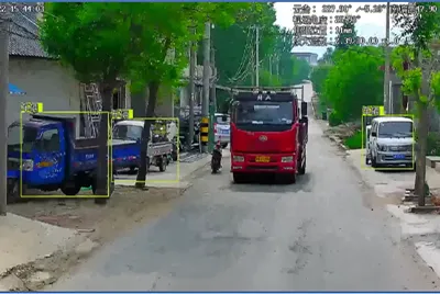
How a Ground Surveillance Radar Detects, Classifies, and Cues a Response
- Wide-area scan. The antenna sweeps its coverage sector using an AESA/DBF (active electronically scanned array / digital beamforming) architecture, which steers the beam electronically instead of mechanically rotating the whole antenna.
- Clutter suppression. Adaptive filtering removes returns from trees, waves, rain, and other background motion, isolating returns that behave like a real moving target.
- Track-before-detect correlation. Weak or slow-moving returns are tracked across several scans before being confirmed as a target. This is what lets the radar pick a crawling person or a slow boat out of background noise instead of discarding the return as clutter on a single scan.
- Classification. Speed, RCS, and movement pattern feed an algorithm that estimates target type: person, vehicle, vessel, or drone.
- Radar-EO slew-to-cue. In a radar-vision fusion configuration, the radar hands the target’s bearing and range to an electro-optical camera, which slews to that position and locks on for visual confirmation.
- Alarm and platform logging. A confirmed detection is pushed to the command platform with a timestamp, track history, and classification tag for the operator to act on.
How a Ground Surveillance Radar Detects, Classifies, and Cues a Response
Connecting the Radar to Your Existing Security Stack
A radar that cannot talk to the existing command platform is a separate alarm source, not a security upgrade. Midradar’s systems support GB/T 28181, ONVIF, and RTSP for video and event interoperability, plus RESTful APIs and SDKs for deeper, custom integration work. ONVIF in particular is the standard most VMS and camera platforms already speak, so a radar that supports it natively tends to drop into an existing video management system without a custom bridge.
Before requesting a quote, it helps to know which VMS, command-and-control platform, access control system, or alarm platform the radar needs to report into. That detail determines which protocol profile gets configured before shipment, and it shortens the back-and-forth during commissioning.
5 Things That Quietly Cut Real-World Range
A rated maximum range describes the radar under close-to-ideal conditions. Several factors at a real site will sit below that number long before the radar itself is the limiting factor.
- Line-of-sight blocking. Ground radar cannot see through terrain. A ridge, building, or earthen berm between the antenna and the target removes the return completely, no matter what the spec sheet says.
- Vegetation and ground clutter. Tall grass, crops, or shrubs moving in wind generate returns that compete with a slow-moving person. This is the main reason personnel detection range in vegetated terrain often lands toward the lower end of the rated band rather than the upper end.
- Heavy rain and fog at higher frequency bands. Signal attenuation increases with frequency, so a system tuned for finer resolution can lose part of its effective range during sustained heavy rain.
- Mounting height and grazing angle. A radar mounted too low sends its beam across the ground at a shallow angle, which weakens returns from low-profile targets well before the rated range is reached.
- Sector width versus revisit time. Scanning a wide sector on every cycle means each target gets fewer “looks” per minute than a narrower sector would provide. Track-before-detect logic compensates for this, but a slow or small target can still take a few extra scan cycles to reach full classification confidence.
None of this makes ground radar unreliable — it’s the same physics every X-band or Ku-band ground sensor on the market deals with. It does mean a site survey, not the datasheet alone, is what determines the real coverage radius for a specific perimeter.
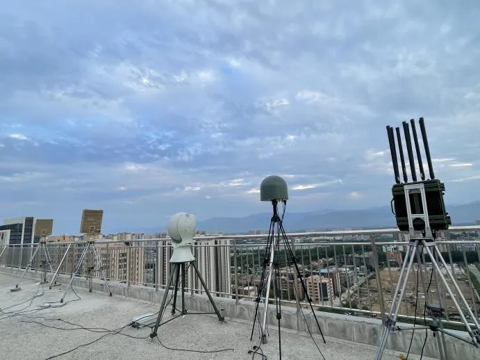
Where Ground Surveillance Radar Gets Deployed
Border lines, coastlines, airport perimeters, ports, and critical-infrastructure sites share one constraint: long boundaries that are too expensive to cover with camera density alone, day and night, in all weather. Midradar’s radar-centered systems are currently deployed across 50+ countries and protect more than 1,000 km of border and coastline. These deployments typically pair ground surveillance radar with electro-optical cameras in a hợp nhất radar và hình ảnh setup, plus a platform layer for alarm management, so detection (radar) and visual confirmation (camera) happen as one workflow rather than two separate systems an operator has to cross-reference manually.
Where Ground Surveillance Radar Gets Deployed
What Ground Surveillance Radar Costs
Midradar does not publish a price list for the RDG series, and for a reasonable reason: the bill of materials changes with the target range required, mounting infrastructure, number of radar-EO fusion stations, protocol integration scope, and the support contract length. Two installations with the same model number can carry different total costs once site-specific mounting and integration work are added. Pricing is quoted per project rather than per catalog unit. A quote request with target distance, dominant threat type (foot traffic, vehicle, or vessel), and terrain description is what gets a usable number back, not a generic price inquiry.
Câu hỏi thường gặp
What is the typical detection range of a ground surveillance radar?
It depends on target type, not a single number. For Midradar’s MR-RDG series, that’s roughly 2–15 km for a person, 5–25 km for a vehicle, and 5–50 km for a vessel.
Can a ground surveillance radar detect a person who is crawling or lying down?
Yes, but at a noticeably shorter range than a standing or walking adult, because a prone body has a much smaller radar cross-section. Sites that specifically need this capability usually pair a shorter-range, higher-resolution model with radar-EO fusion for visual confirmation, rather than relying on a single long-range unit.
Does rain or fog reduce detection range?
Yes. Heavy rain and fog attenuate the radar signal, and the effect is stronger at higher frequency bands. Adaptive clutter suppression reduces false alarms from weather-driven motion, but it does not fully cancel out the range loss itself.
Does ground surveillance radar replace security cameras?
No. It changes what the cameras are used for. The radar handles continuous wide-area detection; cameras (visible-light, thermal, or both) get cued to the target’s bearing for visual identification and evidence capture, rather than scanning empty ground around the clock on their own.
How is ground surveillance radar priced?
Per project, not per catalog listing. Target range, terrain, number of fusion stations, and integration scope all affect the total. Request a quote with your site profile rather than a general price list.
Next step for evaluating this against a specific perimeter: a short site profile, covering approximate boundary length, dominant target type, and terrain, is usually enough for Midradar’s engineering team to recommend an RDG model class and flag any line-of-sight or clutter issues before a site visit gets scheduled.