Wu Kang | Radar System Specialist | Published September 16, 2026
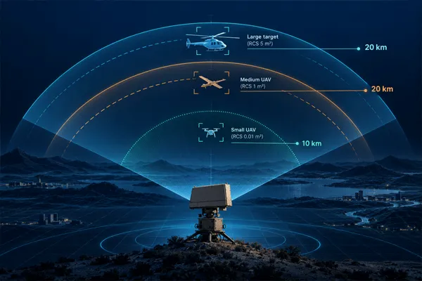
A low-altitude surveillance radar tracks UAVs, small aircraft, birds, and — on several models — ground or water targets moving below roughly 600 to 3,000 meters, at ranges from about 1.5 km for small drones up to 20 km for larger aircraft, depending on the target’s radar cross-section.
Low-Altitude Surveillance Radar Explained: Range & Use Cases
What a Low-Altitude Surveillance Radar Actually Watches For
This is a narrower category than the primary surveillance radar an air traffic control tower relies on, and a different problem from a ground surveillance radar aimed purely at the horizon. A low-altitude unit covers the airspace band where most of the actual security work happens: drone incursions, low-flying aircraft near a perimeter, birds that trigger false alarms on other sensors, and — because several models in this line double as ground radars — vehicles and vessels moving on the surface underneath that airspace.
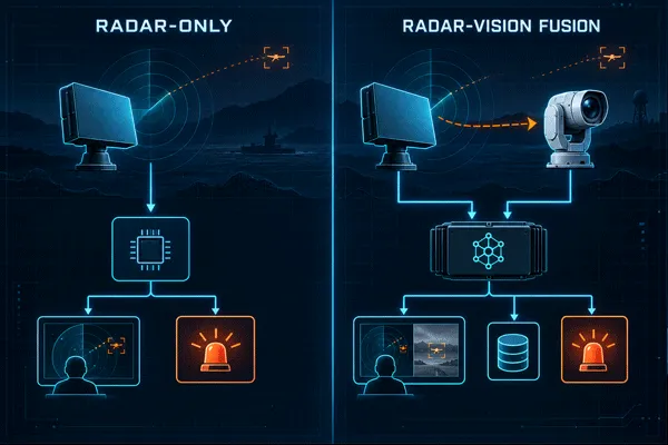
Compared with camera-only or fixed thermal-line perimeter setups, this class of radar extends warning time because detection doesn’t depend on line-of-sight optics or ambient light. A camera has to already be pointed at a threat to see it. A radar sweeping 360 degrees finds the track first and hands a bearing to whatever sensor looks next.
Why Doesn’t Every Radar List the Same Range?
The common mistake in reading a radar spec sheet is treating “detection range” as one number that applies to everything the radar can see. It doesn’t. Range depends on the target’s radar cross-section (RCS) — roughly, how much radar energy a given target reflects back. A truck or a small boat reflects far more energy than a consumer drone, so the same radar publishes very different ranges for each.
Take the MR-RDT20K. Its general-target range is 20 km, and that same 20 km figure applies to vehicles and helicopters. Point it at a small UAV instead, and the published range drops to 10 km — half the distance, same radar, because a small drone’s RCS is a fraction of the reference target used for the general figure. The MR-RDA10K-4R spec sheet goes a step further and adds a weather qualifier: its 10 km small-UAV figure is listed specifically for clear weather. Midradar’s literature describes adaptive clutter suppression for filtering rain, waves, and background motion, but that’s a mitigation for false tracks, not a guarantee that published range holds in a downpour.
The practical takeaway for anyone comparing radars: ask which target class and which environmental condition a published range number assumes, not just what the number is.
Low-Altitude Surveillance Radar Explained: Range & Use Cases
Eight Radars, One Spec Table
The table below covers Midradar’s published low-altitude line as it currently appears on the company’s product pages. RCS and weather qualifiers are kept exactly as published rather than smoothed into a single “detects up to X km” claim.
| Modèle |
Scan architecture |
General / large-target range |
Medium-class target |
Small-UAV range |
Max altitude |
Simultaneous tracks |
Alimentation |
| MR-RDT02K |
3D Ku-band, mechanical + DBF |
3,5 km |
Medium UAV ≥3.5 km (RCS 1 m²) |
≥1.5 km (RCS 0.01 m²) |
600 m |
≥100 |
≤120 W |
| MR-RDT05K |
3D Ku-band, mechanical + DBF |
5 km |
Medium UAV ≥5 km (RCS 1 m²) |
≥3 km (RCS 0.01 m²) |
600 m |
≥200 |
≤180 W |
| MR-RDT10K |
3D X-band, mechanical + DBF |
10 km |
Vehicle/helicopter ≥10 km |
≥5 km |
1 000 m |
≥200 |
≤260 W |
| MR-RDT12K |
X-band 9.8–10 GHz, mechanical + DBF |
Vehicles/ships/helicopters ≥25 km |
Personnel ≥15 km |
DJI Phantom 4-class UAV ≥12 km* |
≤3,000 m |
≥500 |
Not published |
| MR-RDT18K |
3D X-band, mechanical + DBF |
15 km |
Vehicle/helicopter ≥15 km |
≥8 km |
2 000 m |
≥300 |
≤330 W |
| MR-RDT20K |
3D X-band, mechanical azimuth + DBF elevation |
20 km |
Vehicle/helicopter ≥20 km |
≥10 km |
3 000 m |
≥500 |
≤400 W |
| MR-RDA10K-4R |
X-band 2D phased array, monopulse |
Vehicles/ships ≥15 km |
People ≥12 km |
≥10 km, clear weather** |
Not published |
≥500 |
Not published |
| MR-RDA15K-4R |
Four-array 2D AESA |
Vehicle/helicopter ≥8 km |
— |
≥5 km |
1,500 m |
≥500 |
≤1.6 kW total |
*MR-RDT12K’s small-target figure is published against a named consumer drone class rather than a stated RCS value, so it isn’t directly comparable to the RCS 0.01 m² figures used elsewhere in this table.
**A second published product page for the MR-RDA10K-4R lists materially different specifications under the same model name. Treat both pages as provisional and request the current signed datasheet before putting any RDA10K-4R figure into a tender document.
Two Scanning Approaches Behind These Numbers
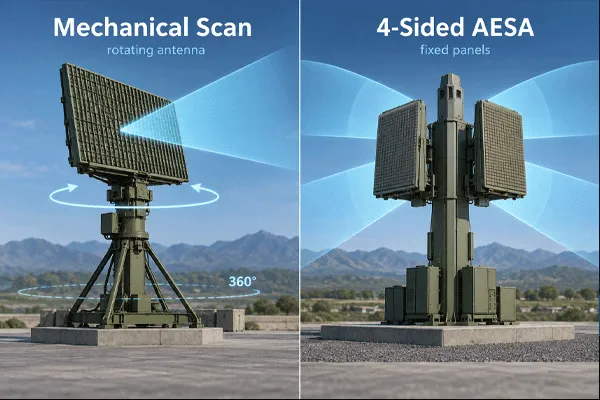
The RDT-series units scan mechanically: a rotating antenna combined with digital beamforming (DBF) on elevation gives 360-degree coverage by physical rotation, which is why MR-RDT12K and MR-RDT20K both list a flat 360-degree azimuth figure. It’s a simpler, lower-power design, and it’s why this sub-line runs from 120 W up to 400 W rather than into the kilowatt range.
The RDA-series units use a four-array phased design instead. Each face steers electronically and covers roughly 90 degrees on its own; stitched together, the four faces cover the full circle. MR-RDA10K-4R states this explicitly — 90 degrees per face, 360 degrees as a system — which is useful precision, but it also means a buyer has to read the per-face number and the system number as two different things rather than assuming one radar head equals one coverage figure.
How Radar Cues the Camera: Slew-to-Cue Integration
A radar track by itself is a bearing, a range, a speed, and sometimes an altitude — not a picture. Midradar’s radar-EO fused products, such as the MR-RD02SE-DMS15-AU Radar-EO Detection System, pair one of the radar heads above with visible-light imaging, infrared thermal imaging, and a servo pan-tilt, run through the RGS2000 platform.
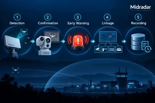
The handoff between radar and camera works in roughly five steps:
- The radar detects a track crossing a configured threshold — range, speed, or a defined zone.
- Track data (bearing, elevation, speed) passes to the platform software in real time.
- The platform commands the pan-tilt unit to slew the EO payload to that bearing automatically. Midradar’s own material calls this “radar-EO intelligent slew-to-cue.”
- The camera zooms to the target’s range and an operator, or the platform’s AI target recognition where it’s deployed, confirms whether the track is a drone, a bird, a vehicle, or a false detection.
- Confirmed threats get logged and can trigger an alarm, or an acoustic/optical deterrent response, through the same platform.
Whether this integrates cleanly with an existing security stack usually comes down to protocol support before it comes down to radar range. Midradar’s platforms support GB/T 28181, ONVIF, and RTSP for connecting to third-party video management or command-and-control systems, along with RESTful APIs and SDKs for tighter integration work. Checking that list against whatever VMS or C2 platform is already running is worth doing before a spec is finalized, not after.
Low-Altitude Surveillance Radar Explained: Range & Use Cases
Where This Gets Deployed
- Airport perimeters and approach corridors.Detecting drones, birds, and unauthorized light aircraft near runways, where a false alarm from a flock of birds and a genuine drone incursion need to be told apart quickly.
- Energy and critical-infrastructure sites.Flagging drone incursions over transmission lines, substations, or storage tanks before they reach visual range on a fixed camera.
- Border and coastal zones.The same low-altitude line’s vehicle and vessel figures (10–25 km depending on model) cover ground and water targets underneath the airspace being watched; Midradar’s surface-radar line extends further still, with the MR-RDG50K rated at 50 km or more against large vessels for sites that need both layers.
- Temporary or event-driven airspace monitoring.Quick-deploy radar coverage supplements fixed camera lines that can’t see past the horizon or in low light, across the roughly 1,000 installations in 50-plus countries the company’s radar and security systems have gone into to date.
What the Radar Won’t Tell You Alone
The strengths of this line are consistent across the table above: day/night operation, detection that isn’t limited to line of sight, and up to 500 simultaneous tracks on the higher-end models. That said, a few things don’t come from the radar head by itself.
- Identification isn’t automatic.A raw track tells you something is moving at a given bearing and speed. Telling a bird from a small drone reliably still depends on EO cueing or an operator, not the radar data alone.
- Clutter produces false tracks.Adaptive clutter suppression filters out trees, waves, rain, and background motion, but flocking birds and dense clutter environments can still generate detections that need a second sensor to rule out.
- Altitude ceilings vary sharply by model.A unit sized for a small perimeter (MR-RDT02K, 600 m) won’t cover the altitude band an approach corridor near a runway typically needs (MR-RDT20K or MR-RDT12K, up to 3,000 m).
- One model in this line has two conflicting public spec sheets.The MR-RDA10K-4R discrepancy noted above is a sourcing problem, not a product defect, but it means self-service research on this specific model isn’t reliable without a current datasheet in hand.
- Pricing isn’t published for any model in this line.All eight units above require a direct quote request; there’s no public price range to reference.
FAQ
What altitude range does a low-altitude surveillance radar actually cover?
It varies by model — from 600 m on the compact MR-RDT02K up to 3,000 m on the MR-RDT12K and MR-RDT20K. There's no single ceiling across the product line.
Can this type of radar detect small consumer drones as well as aircraft?
Yes, but at a shorter range than it detects larger targets. Small-UAV figures (RCS around 0.01 m²) typically run at roughly half the range published for vehicles or general large targets on the same unit.
Does weather reduce the published detection range?
It can. At least one model in this line, the MR-RDA10K-4R, explicitly qualifies its small-UAV range as a clear-weather figure. Adaptive clutter suppression helps with rain and wave clutter but isn't described as eliminating range loss in adverse conditions.
Is a camera required, or can the radar operate on its own?
The radar can operate alone for detection and tracking. Positive identification of what a track actually is — drone, bird, vehicle, false alarm — depends on pairing it with EO/thermal cueing through a radar-EO product or platform integration.
How much does a low-altitude surveillance radar system cost?
Midradar doesn't publish pricing for any model in this line. Quotes are issued per project based on model, quantity, and integration scope.


 12:02
12:02