PROJECT SNAPSHOT
| Ngành công nghiệp |
Petrochemical / Refining & Storage |
| Region |
East Asia — coastal refinery and storage complex |
| Environment |
Large tank farm and refinery complex with hazardous-area zones, an 8+ km open-boundary perimeter, loading terminal, and adjacent public road access |
| Threat Profile |
Unauthorized personnel intrusion; vehicle trespass at unmanned access routes; low-altitude UAV reconnaissance over restricted production areas |
| Core Challenge |
Legacy electronic fence and CCTV: high nuisance alarm rate, no early warning range, no UAV detection capability, no structured evidence chain |
| Radar Deployed |
3 × MR-RDT20K Low-Altitude Surveillance Radar |
| Camera Deployed |
9 × MR-HTVC12035-2132 Long-Range PTZ Thermal Camera |
| Platform |
Radar-video fusion perimeter management platform — virtual fence zoning, multi-target tracking, threat grading, EO/IR auto-linkage, alarm evidence recording |
| Project Duration |
18 months (10 months construction + 8 months operational tuning) |
| Key Outcome |
24/7 all-weather coverage of the full tank farm boundary with automated multi-threat classification across personnel, vehicles, and UAVs |
BACKGROUND
Large petrochemical tank farms present a security challenge that most standard surveillance infrastructure is poorly equipped to address. Extensive open-boundary perimeters, continuous 24-hour operations, and hazardous-area equipment restrictions combine to create conditions where conventional CCTV and electronic fence systems consistently underperform.
This facility is a major tank farm and refinery complex located on the East Asian coast. The site boundary exceeds 8 kilometres, spanning liquefied hydrocarbon storage areas, process units, a product loading terminal, and administrative zones — with Zone 1 and Zone 2 hazardous-area classifications covering large portions of the site.
Three threat categories had become operationally significant before the upgrade:
- Unauthorized personnel intrusion: Night-time intrusion attempts along extended perimeter sections where legacy infrared beam detectors generated high nuisance alarm rates from environmental disturbance, eroding effective operator response.
- Vehicle trespass: Unmanned access routes and loading terminal approaches periodically subject to unauthorized vehicle entry — visible only on CCTV after the vehicle was already on-site.
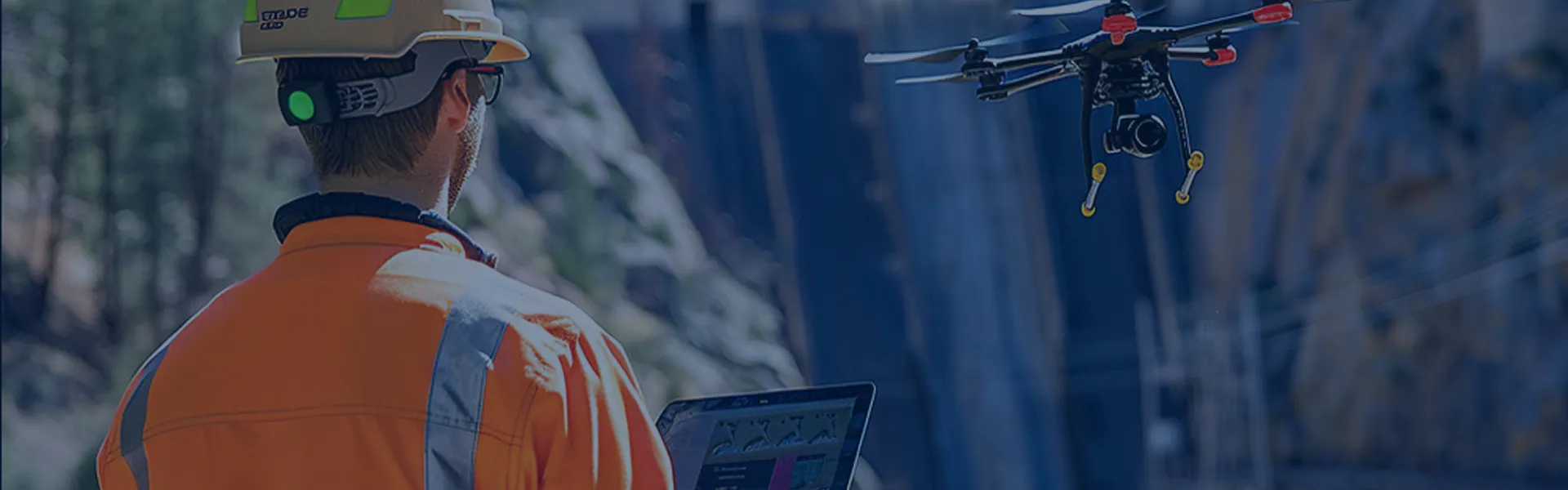
- Low-altitude UAV reconnaissance: An increasing pattern of unmanned aerial vehicles observed over restricted production areas — a threat dimension the existing system had no capability to detect or classify.
The legacy system had two structural limitations: no early warning range (every alarm triggered only when a target physically contacted the boundary), and no target classification (personnel, vehicles, and environmental disturbances all generated the same undifferentiated alert).
HOW THE SYSTEM WORKS
The deployed system follows Midradar’s six-step perimeter protection workflow:
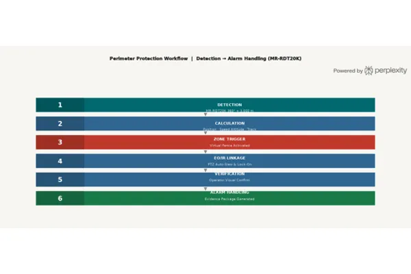
| 1 — DETECTION |
MR-RDT20K radar continuously scans the full 360° azimuth and up to 3,000 m altitude, simultaneously monitoring ground targets and low-altitude airspace. |
| 2 — CALCULATION |
The platform computes each detected target’s position, speed, altitude (for airborne targets), and projected trajectory in real time. |
| 3 — ZONE TRIGGER |
If a target’s path intersects a configured zone (ground boundary perimeter, vehicle exclusion area, tank buffer, or UAV alert envelope), the zone’s alarm rule triggers automatically. |
| 4 — EO/IR LINKAGE |
The nearest MR-HTVC12035-2132 PTZ thermal camera slews automatically to the target’s coordinates and begins tracking. |
| 5 — VERIFICATION |
Operators receive simultaneous radar track and thermal/visible video on a single display for immediate visual confirmation. |
| 6 — ALARM HANDLING |
Each event generates a complete evidence package: snapshot, video clip, radar track, GPS coordinates, target classification, and threat-level score. |
SOLUTION
MR-RDT20K — Low-Altitude Surveillance Radar
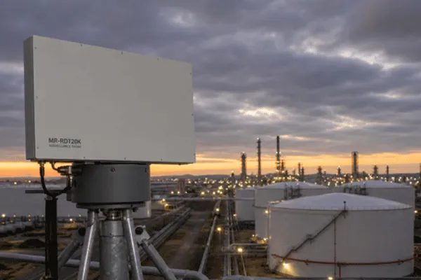
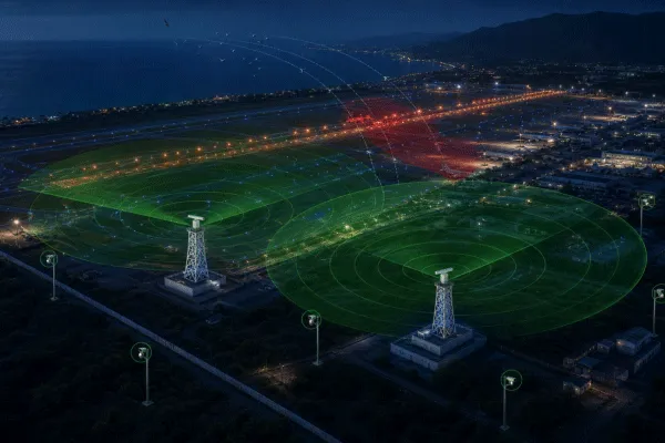
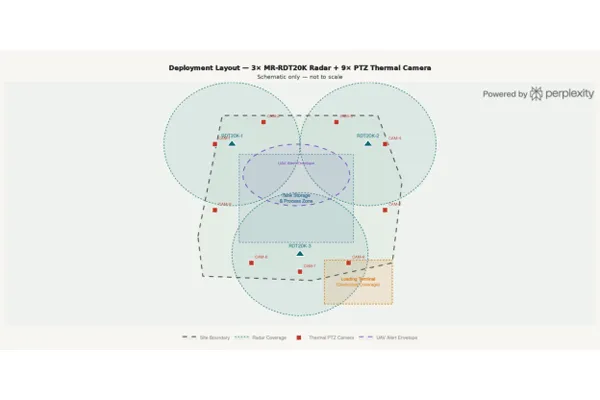
Three MR-RDT20K low-altitude surveillance radars deliver continuous 360° detection of both ground-level intruders and low-altitude aerial targets across the full perimeter and internal restricted zones. The MR-RDT20K was selected on three site-specific grounds:
· Strong clutter suppression for reliable personnel detection in the complex industrial ground environment without unacceptable false alarm rates.
· Three-dimensional detection capability (mechanical azimuth scan + elevation DBF) covers both ground targets and the UAV threat within a single sensor, eliminating the need for separate counter-UAV radar infrastructure.
· 500-target tracking capacity with 1–3 second refresh rates handles simultaneous target density typical of a busy industrial perimeter without performance degradation.
Key Technical Specifications — MR-RDT20K:
| Dải tần số hoạt động |
Băng X |
| Công nghệ |
Quét góc phương vị cơ học + Góc nâng DBF |
| Phạm vi phát hiện |
20 km |
| Max Detection Altitude |
3,000 m |
| Vùng mù |
50 m |
| Phạm vi góc phương vị |
360° |
| Phạm vi độ cao |
−5° to 60° |
| Phạm vi đo vận tốc |
1–150 m/s |
| Phát hiện máy bay không người lái cỡ nhỏ |
≥ 10 km |
| Medium UAV / Vehicle / Helicopter Detection |
≥ 20 km |
| Độ chính xác của tầm bắn |
≤ 5 m |
| Độ chính xác về vận tốc |
≤ 0.5 m/s |
| Độ chính xác góc |
≤ 0.3° |
| Tần số làm mới |
1 s / 2 s / 3 s |
| Khả năng theo dõi |
≥ 500 targets |
| Nhiệt độ hoạt động |
−40 °C to +55 °C |
| Mức độ bảo vệ |
IP66 (host IP67) |
| Tiêu thụ điện |
≤ 400 W |
| Khối lượng |
≤ 55 kg (host + pedestal) |
MR-HTVC12035-2132 — Long-Range PTZ Thermal Camera
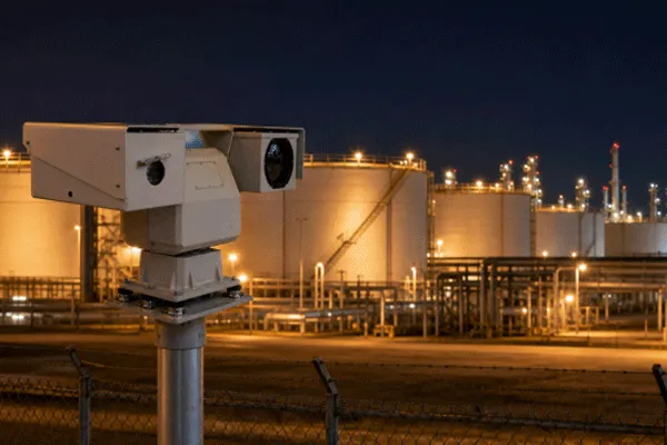
Nine units are deployed at mast positions co-located with radar masts, rooftop positions on main control buildings and warehouse structures, and dedicated positions covering loading terminal approaches and the main vehicle access gate.
The thermal camera provides 3.3 km personnel recognition range and 30× optical zoom on the visible-light channel — enabling both nighttime personnel verification and daytime licence plate-level detail at loading terminal positions within a single unit.
| Detection Range (vehicle / human) |
21 km / 9 km |
| Recognition Range (vehicle / human) |
7 km / 3.3 km |
| Cảm biến nhiệt |
VOx uncooled, up to 1280×1024 resolution |
| NETD |
45 mK |
| Ống kính nhiệt |
25 mm – 325 mm, 13× continuous zoom, autofocus |
| Camera có thể nhìn thấy |
2.1 MP, 1/1.8″ CMOS, 0.0002 lux minimum illumination |
| Ống kính nhìn thấy được |
4.3 mm – 141 mm, 30× optical zoom |
| PTZ Pan |
0°–360° liên tục |
| Phân tích thông minh |
Intrusion detection, fire/heat alarm, auto-tracking |
| Nhiệt độ hoạt động |
−35 °C to +60 °C |
| Mức độ bảo vệ |
IP66, triple-proof coating |
Unified Perimeter Management Platform
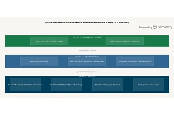
· GIS-based unified display: radar tracks (ground and aerial), thermal and visible video, virtual fence overlays, and site map on one operator interface.
· Multi-zone virtual fence management: independent alarm configurations for ground boundary perimeter, vehicle exclusion areas, tank buffer zones, and UAV alert envelopes above restricted production zones.
· Multi-threat classification: real-time target type labels per track (personnel / vehicle / small UAV / medium UAV) with position, altitude, speed, trajectory, and zone status.
· Threat-level assessment: automated priority scoring based on target type, altitude profile, direction of travel, zone proximity, and behavioral pattern.
· Alarm evidence recording: per-event package including snapshot, video clip, radar track, timestamp, GPS coordinates, target classification, and threat score — structured for incident review, regulatory reporting, and insurance documentation.
· Integration-ready: open interfaces for access control, lighting, speaker warning, and counter-UAV effector systems.
DEPLOYMENT HIGHLIGHTS
Hazardous-Area Equipment Compliance: Zone 1 and Zone 2 classifications cover significant portions of the site. A formal hazardous-area review prior to procurement mapped each sensor position against the zone classification drawing. Equipment within classified zones was specified to meet applicable explosion-proof or intrinsically safe certification. Mast and camera positions were sited at zone boundaries wherever practical to minimize classified-area hardware.
Three-Sector Radar Coverage Design: The 8+ km perimeter was divided into three radar coverage sectors anchored by MR-RDT20K mast positions. Coverage modeling confirmed adequate overlap at each sector boundary for continuous target track handoff across both the ground layer and the low-altitude airspace envelope, eliminating detection gaps in both dimensions.
Loading Terminal Dedicated Coverage: The loading terminal and main vehicle access gate were designated as high-consequence areas requiring coverage independent of the standard perimeter radar scheme. Two MR-HTVC12035-2132 units at these positions provide both radar-cued thermal tracking and independently triggered visible-light vehicle monitoring.
18-Month Timeline as a Planning Reference: The overall 18-month duration — 10 months construction, 8 months operational tuning — reflects a realistic baseline for large petrochemical perimeter deployments of this complexity. The tuning phase calibrates alarm thresholds for ground and aerial targets against one full cycle of operational activity before formal handover.
OUTCOMES
Following commissioning and the 8-month operational tuning phase, the security operations team confirmed the following improvements:
· Full-boundary all-weather coverage: the 8+ km perimeter is continuously monitored by overlapping radar sectors regardless of lighting or weather.
· First-ever UAV detection capability: the facility gained the ability to detect, classify, and track low-altitude UAV targets entering restricted production airspace.
· Pre-boundary early warning: ground targets are detected and tracked at range before reaching the fence line — shifting the response model from reactive containment to pre-emptive interception.
· Nuisance alarm reduction: per the security team’s internal operational review, nuisance alarm events requiring response were substantially reduced within the first three months following tuning completion.
· Single operational view for three threat types: personnel intrusion, vehicle trespass, and UAV activity are classified and displayed within the same operator interface.
· Structured per-incident evidence: every alarm event is logged with a complete evidence package supporting security review, regulatory audit trail requirements, and insurance documentation.
FREQUENTLY ASKED QUESTIONS
Q: Why is radar necessary — can thermal cameras alone cover an 8 km petrochemical perimeter?
A single thermal camera covers a defined field of view. Covering 8 km with cameras alone requires either a very large number of fixed units or continuous manual PTZ operation — neither of which provides reliable autonomous early warning. The MR-RDT20K scans the full 360° azimuth and up to 3,000 m altitude simultaneously, detecting and tracking multiple ground and aerial targets across the full perimeter in a single sensor. Thermal cameras provide visual verification for targets the radar has already located, rather than serving as the primary detection layer.
Q: How does the system classify personnel, vehicles, and UAVs in the same operational picture?
The MR-RDT20K uses mechanical azimuth scanning combined with elevation digital beam forming (DBF) to acquire three-dimensional target data — range, speed, azimuth, and altitude. Combined with radar cross-section analysis and velocity profiling, the system classifies each track at signal processing level. The platform displays these labels per track in real time. For events requiring confirmation, the MR-HTVC12035-2132 provides thermal and visible-light visual verification.
Q: How are explosion-proof requirements handled for equipment within hazardous zones?
A formal hazardous-area review maps each sensor position against the site’s zone classification drawing before procurement. Equipment within classified zones is specified to meet applicable explosion-proof or intrinsically safe certification. Mast positions are sited at zone boundaries wherever possible to minimize classified-area hardware.
Q: How long does commissioning typically take for a large petrochemical perimeter project?
This deployment ran 18 months in total: 10 months of construction and physical installation, followed by 8 months of operational tuning. For a comparable 8+ km boundary with both ground and aerial threat zones, this is a realistic planning baseline. The tuning phase calibrates alarm thresholds against actual operational conditions before handover.
Q: Can this solution integrate with an existing access control or CCTV system?
Yes. The platform uses an open integration architecture with standard interfaces for access control systems, existing CCTV infrastructure, lighting control, and speaker-based verbal warning. The platform also supports open interfaces to counter-UAV effector systems for sites requiring active UAV mitigation capability.
Q: What ongoing maintenance does this system require?
Recommended activities include periodic antenna and optics cleaning, firmware updates, and an annual alarm threshold review to account for changes in the operational environment. Midradar provides remote diagnostic capability to support maintenance scheduling without requiring on-site attendance for routine checks.
Q: What site information is needed to scope a radar perimeter solution for a tank farm?
Key inputs: perimeter boundary length and geometry, hazardous-area zone classification drawing, current threat profile (ground and aerial), existing sensor infrastructure to be retained or integrated, and power and communications availability at candidate mast positions.
Q: Does this solution support regulatory reporting and audit trail requirements?
Yes. The platform records a complete structured evidence package for every alarm event — snapshot, video clip, radar track, timestamp, GPS coordinates, target classification, and threat-level score — retained in queryable log format. Teams can generate time-period reports, zone-specific summaries, and event-level detail exports for regulatory audit, insurance review, or internal investigation.
Q: Can the system be extended to cover pipeline routes and off-site infrastructure in the future?
Yes. Additional MR-RDT20K radar nodes and camera units can be added as separate coverage segments within the same platform, with unified alarm management across all areas. New virtual fence zone configurations can be added and tested independently without affecting the operational status of existing zones.
EXPLORE RELATED SOLUTIONS
· MR-RDT20K Low-Altitude Surveillance Radar
· MR-HTVC12035-2132 Long-Range PTZ Thermal Camera
· Perimeter Protection Solution
· Integrated Counter-UAV System
· Airport Bird Strike Prevention Case Study