Executive Summary
Selecting a drone detection and low-altitude surveillance radar supplier is one of the most consequential procurement decisions a security organization faces. These systems protect airports, seaports, energy facilities, industrial parks, oil and gas installations, power utilities, smart city infrastructure, and public venues from unauthorized drone activity — 24 hours a day, in all weather conditions.
Key Takeaways:
· Never evaluate radar specifications before defining a threat model. A “20 km detection range” is meaningless without a target RCS value.
· Consumer drones (DJI Phantom class) have an RCS of approximately 0.01 m² — the same order of magnitude as a large bird. AI-based micro-Doppler classification accuracy matters more than raw detection range.
· AESA (solid-state) radar costs more upfront but has a 10–15 year lifecycle with near-zero mechanical maintenance, delivering lower total cost of ownership than mechanical scan systems over a 10-year horizon.
· Single-sensor solutions (RF-only, camera-only) cannot detect pre-programmed RF-silent drones. Only radar-primary or radar-RF fusion architectures provide comprehensive coverage.
· Open API/SDK support (GB/T 28181, ONVIF, RTSP, RESTful) is non-negotiable for systems integrators adding a radar layer to existing VMS or PSIM platforms.
· The global drone detection market is projected to grow from $3.2 billion in 2025 to $19.8 billion by 2033 (CAGR 25.2%).
Industry Statistics: Why Drone Detection Investment Is Accelerating
· Global drone detection market: $3.2B in 2025 → $19.8B by 2033 at CAGR 25.2%
· Drone incidents at airports increased 44% between 2022 and 2024 (Source: EUROCONTROL)
· FAA recorded over 1.7 million drone registrations in the US as of 2025
· Over 2,000 drone security incidents recorded at European airports between 2018 and 2024 (Source: EUROCONTROL DRONE_IQ)
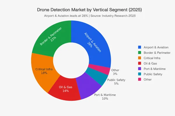
Market by Vertical Segment (2025):
| Vertical |
Share |
Key Driver |
| Airport & Aviation |
28% |
FAA/ICAO/EASA regulatory pressure |
| Border & Perimeter |
22% |
Government infrastructure investment |
| Critical Infrastructure |
18% |
Energy sector, data centers, utilities |
| Oil & Gas |
14% |
Facility protection |
| Port & Maritime |
10% |
Cargo security, smuggling prevention |
| Public Safety |
5% |
Event security, urban surveillance |
| Other |
3% |
Research, smart cities |
Regulatory Tailwinds (2026):
· FAA (USA): Proposed rule (May 2026) establishes a formal petition process for critical infrastructure operators to create drone exclusion zones.
· ICAO: Doc 10019 (Manual on RPAS) provides the international framework for airport drone detection.
· EU: EU Drone Regulation (EU 2019/945, EU 2021/664) mandates registration and operational categories.
· EUROCONTROL: DRONE_IQ initiative systematically collects drone incident data to inform detection equipment performance standards.
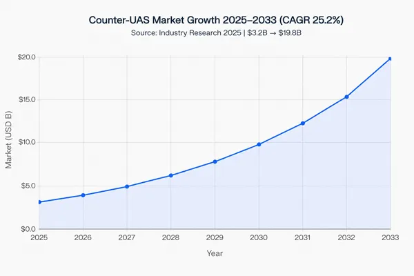
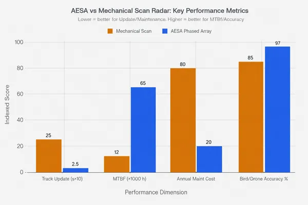
Table of Contents
1. Why Procurement Often Fails
2. Step 1 — Define Your Threat Model
3. Step 2 — Understand the Three Radar Categories
4. Step 3 — Evaluate Core Technical Specifications
5. Step 4 — Multi-Sensor Fusion Architecture
6. Step 5 — Certifications & Compliance
7. Step 6 — Field Trials: Nine Standard Scenarios
8. Step 7 — Supplier Track Record & Support
9. Common Procurement Mistakes
10. Total Cost of Ownership (TCO)
11. How to Compare Suppliers
12. Procurement Journey & Process
13. Case Studies: Five Vertical Applications
14. ROI Framework
15. Complete Evaluation Checklist
16. Glossary
17. FAQ (15 Questions)
18. Download Resources
Why Drone Detection Procurement Often Fails
The five root causes of procurement failure appear consistently across airports, critical infrastructure, and border deployments:
1. Threat model skipped. Procurement begins with vendor demonstrations rather than operational requirements. Systems are selected on price and marketing materials, not mission fit.
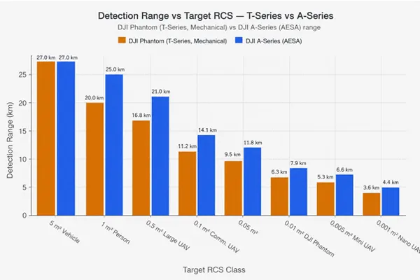
2. Detection range misread. “20 km detection range” means 20 km against a target with RCS ≥ 1 m² — a person or vehicle. Against a consumer drone (RCS ≈ 0.01 m²), effective range may be 3–8 km. This single misunderstanding causes the most post-deployment disappointment in the industry.
3. False alarm rate ignored. A system generating 50+ false alarms per hour due to birds will be disabled by operators within weeks. No one asks about false alarm rates during procurement because no one thinks to ask.
4. RF-only thinking. RF/spectrum detection is blind to pre-programmed autonomous drones that emit no RF signal. Organizations deploying RF-only systems have a systematic detection blind spot for an increasingly common threat class.
5. Integration underestimated. A radar that cannot connect to existing VMS or PSIM platforms requires parallel workflows. Integration timelines of 6–18 months — originally estimated at 4–6 weeks — are common when API documentation is inadequate.
Step 1: Define Your Threat Model
Before contacting any supplier, your threat model must address six dimensions:
Drone Class and RCS
| Drone Class |
Typical RCS |
Velocità |
RF-Silent Capable? |
Example |
| Nano / Micro-UAV |
0.001–0.005 m² |
5–15 m/s |
Sì |
Custom FPV (carbon fiber) |
| Mini / Consumer UAV |
0.005–0.02 m² |
5–20 m/s |
Increasingly |
DJI Mini 4 Pro |
| Standard Consumer UAV |
0.01–0.05 m² |
10–25 m/s |
Mostly No |
DJI Phantom 4, Matrice 300 |
| Commercial / Large UAV |
0.05–0.5 m² |
15–50 m/s |
Sì |
Fixed-wing operational |
| Large UAV |
0.5–5 m² |
20–80 m/s |
Sì |
Government-grade |
RF Profile (Critical Dimension)
| RF Profile |
RF Sensor Effective? |
Radar Effective? |
| Standard RC protocol (2.4/5.8 GHz) |
Sì |
Sì |
| Encrypted proprietary link |
Partial |
Sì |
| RF-silent (GPS pre-programmed) |
No |
Sì |
Operating Environment
| Environment |
Primary Challenge |
What to Prioritize |
| Open border / desert |
Long range, dust ingress |
IP67, range at RCS 0.01 m², temp range |
| Dense urban |
Building clutter, multipath |
Clutter rejection, angular accuracy |
| Coastal / maritime |
Sea clutter at low elevation |
CFAR algorithm, elevation filter |
| Airport |
Air traffic, RF congestion |
TCAS integration, spectrum clearance |
| Mountain / high altitude |
Terrain masking, weather extremes |
Operating temperature, coverage geometry |
| Major public event |
Temporary deployment, urban clutter |
Fast setup, low false alarms |
Step 2: Understand the Three Radar Categories
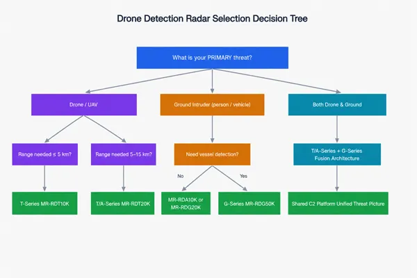
Quick selection guide:
Three questions determine your category:
(1) Is the primary threat a drone or a ground intruder?
(2) What detection range is required?
(3) Is 360° continuous coverage needed?
Category 1: Low-Altitude UAV Detection Radar
| Tecnologia |
Scan Method |
Advantages |
Limitations |
| Mechanical Scan (FMCW) |
Rotating antenna |
Lower CapEx, longer max range per cost |
Moving parts, slower update rate |
| AESA |
Electronic beam steering |
No moving parts, 0.25 s TAS update, software-configurable |
Higher CapEx |
| PESA |
Electronic beam steering |
No moving parts, lower cost than AESA |
Less flexible beam management |
Midradar Product Reference:
| Modello |
Tecnologia |
Detection Range (RCS 0.01 m²) |
360° |
Track Update |
| MR-RDT10K |
Ku-band Mechanical + DBF |
~3–5 km |
✅ |
2–3 s |
| MR-RDT20K |
Ku-band Mechanical + DBF |
~5–10 km |
✅ |
2–3 s |
| MR-RDA10K-4R |
X-band AESA (4 panels) |
~5–8 km |
✅ |
0.25 s TAS |
| MR-RDA15K-4R |
X-band AESA (4 panels) |
~8–15 km |
✅ |
0.25 s TAS |
Category 2: Ground Surveillance Radar
| Modello |
Tecnologia |
Personnel |
Vehicle |
Vessel |
| MR-RDG06K |
Banda Ku |
2–6 km |
5–10 km |
5–15 km |
| MR-RDG20K |
X-band 1D-AESA |
8–15 km |
15–20 km |
20–30 km |
| MR-RDG50K |
X-band 1D-DBF |
12–15 km |
20–25 km |
30–50 km |
Category 3: Radar-Vision Fusion Systems
| Modello |
Person Range |
Telecamera |
Thermal |
Il migliore per |
| MR-RDS500-4R |
500 m |
43× HD |
— |
Urban perimeter posts |
| MR-RDS500-50M-4R |
500 m |
30× HD |
50 mm |
Night surveillance |
| MR-RDS1000-307M |
1,000 m |
37× HD |
— |
Mid-range checkpoints |
| MR-RDS2000-100M |
2,000 m |
50× HD |
100 mm |
Long-range border nodes |
Step 3: Evaluate Core Technical Specifications
3.1 Detection Range by Target RCS
| Object / Intruder Type |
Typical RCS |
What to Request |
| Large Vehicle |
~5–10 m² |
Ground surveillance benchmark |
| Person (standing) |
~0.5 m² |
Perimeter intrusion detection |
| Large UAV |
~0.1–0.5 m² |
Commercial or operational drone |
| Consumer Drone (DJI Phantom) |
~0.01 m² |
Primary UAV detection benchmark |
| Mini Drone / FPV |
~0.001–0.005 m² |
High-risk / high-security environments |
Rule: Never accept an unqualified detection range figure. Always request range at RCS 0.01 m² for drone detection applications.
3.2 Track Update Rate
| Update Rate |
Applicazione |
| 2–3 s |
Standard mechanical scan; slow/hovering targets |
| 0.5–1 s |
Fast mechanical or PESA; improved tracking |
| 0.25 s (TAS) |
AESA Track-After-Scan; fast-maneuvering drones |
3.3 Range and Angular Accuracy
- · Range accuracy ≤ 5 m RMS — places target within camera FOV at 1 km
- · Angular accuracy ≤ 0.5° RMS — 8.7 m lateral error at 1 km
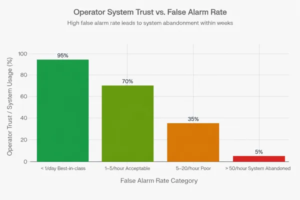
- · Velocity accuracy ≤ 0.5 m/s — required for trajectory prediction
3.4 False Alarm Rate and AI Classification
False alarm cascade failure:
High false alarm rate → Operator fatigue → Real intrusion alarm ignored → Security breach → System disabled → Zero protection
Operational thresholds:
- · < 1/day: Best-in-class; required for automated response systems
- · < 5/hour: Acceptable for staffed operations centers
- · 50/hour: System will be operationally abandoned within weeks
AI classification trained on million-sample micro-Doppler libraries achieves >95% bird/drone discrimination in field conditions (Midradar specification).
3.5 Simultaneous Track Capacity
| Scenario |
Minimum Tracks Needed |
| Single-site facility |
50–200 |
| Airport (mixed traffic) |
500+ |
| Border multi-target |
200–1,000 |
| Swarm response |
1,000–2,000+ |
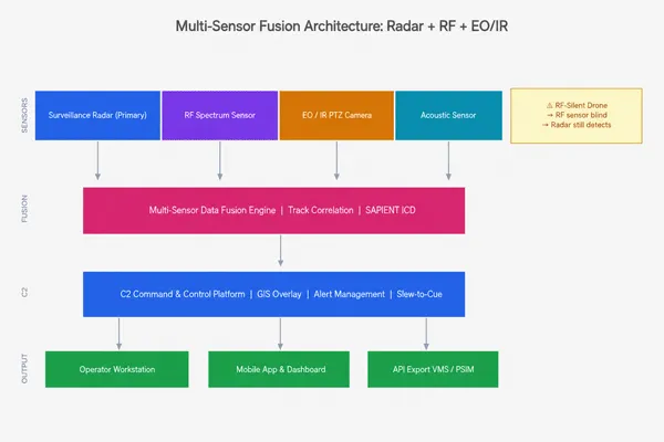
Step 4: Multi-Sensor Fusion Architecture
Sensor Layer Comparison
| Sensore |
RF-Silent Detection |
All-Weather |
Provides Identity |
Range |
| Surveillance Radar |
Sì |
Sì |
No |
Long (km) |
| RF Spectrum Sensor |
No |
Sì |
Partial |
Medium |
| EO/IR PTZ Camera |
(short range) |
Partial |
Sì |
Short–Medium |
| Acoustic Sensor |
Sì |
Sì |
Partial |
< 1 km |
Slew-to-Cue Process
- Radar detects and tracks object (range, azimuth, elevation)
- C2 softwareconverts coordinates to PTZ pan/tilt angles
- PTZ cameraauto-slews to calculated position
- AI vision system acquires and classifies object on screen
- Target: < 5 seconds from detection to operator visual confirmation
Integration Protocol Checklist
| Protocollo |
Use Case |
| GB/T 28181 |
IP camera / recorder integration |
| ONVIF Profile S/T |
IP camera interoperability |
| RTSP |
Video stream for VMS |
| RESTful API |
C2 / PSIM / custom integration |
| SAPIENT ICD |
Multi-vendor government platform |
| ASTERIX Cat 240/48 |
Airport ATM integration |
Step 5: Certifications and Compliance
| Certification |
Required For |
| CE (RED) |
EU member state deployment |
| FCC Part 15/90 |
United States |
| UKCA |
United Kingdom |
| ISO 9001 |
Government procurement worldwide |
| IP66 / IP67 |
Outdoor 24/7 all-weather operation |
| IEC 60068-2 |
Environmental testing |
| EMC (EN 55032) |
Electromagnetic compatibility |
Operating temperature: Minimum −40°C to +55°C for cross-environment deployments.
Spectrum licensing timeline: 6–18 months at major airports. Start BEFORE procurement closes.
Step 6: Field Trials — Nine Standard Scenarios
| # |
Test Scenario |
What It Tests |
Key Metric |
| 1 |
Hovering object — 60 s stationary at 500 m, 1 km, 3 km |
Minimum-Doppler track continuity |
No track drop |
| 2 |
Erratic maneuver — Rapid zig-zag and altitude changes |
Non-linear motion tracking |
No track drop |
| 3 |
Multi-elevation approach — Horizon-level then ascend |
Vertical coverage gaps |
Detection at all elevations |
| 4 |
Slew-to-cue timing — Detection to camera frame acquisition |
Handoff accuracy and speed |
< 5 s, target in frame |
| 5 |
Slow-flight — 1–4 m/s (payload-carrying profile) |
Doppler filter low-velocity cutoff |
Detection confirmed |
| 6 |
Night / thermal — Radar + thermal camera confirmation |
Thermal effectiveness at range |
Target identified |
| 7 |
Adverse weather — Rain ≥ 10 mm/hr, wind ≥ 40 km/h |
All-weather verification |
Track maintained |
| 8 |
RF-silent object — Pre-programmed autonomous flight |
Radar-only detection |
Detection without RF |
| 9 |
Swarm — Three or more simultaneous objects |
Multi-target track ID assignment |
Unique ID per object |
Critical requirement: Test in your operating environment — not at the supplier’s demonstration site.
Step 7: Supplier Track Record and Support
Qualification questions:
· Total installations by geography and environment type?
· Core components (TR modules, GMTI algorithms, C2 software) developed in-house?
· Algorithm update frequency and remote delivery capability?
· Site survey, RF propagation modeling, and acceptance testing included?
· 24/7 remote diagnostic support available?
Red flags:
| Red Flag |
Risk |
| Unqualified detection range (no RCS) |
Systematic range overstatement |
| All references in one geography |
Performance unverified in your environment |
| No algorithm update history |
Classification degrades as new drones enter market |
| API documentation not available until after purchase |
Integration far harder than represented |
| RF-only or camera-only as primary sensor |
Detection blind spot for RF-silent objects |
Common Procurement Mistakes
Mistake 1: Selecting by Maximum Detection Range
“25 km detection range” applies to a 1 m² vehicle. Against a 0.01 m² drone, effective range may be 4–8 km. Fix: Require RCS-qualified ranges in all RFI responses.
Mistake 2: Ignoring Track Refresh Rate
At 2-second update rate, an object at 20 m/s moves 40 m between updates — outside any PTZ FOV. Fix: Require 0.25 s TAS for AESA.
Mistake 3: Ignoring False Alarm Rate Until Deployment
100+ bird alarms/day → operators disable system → zero protection. Fix: Require false alarm rate measurement as a formal bid requirement.
Mistake 4: RF-Only Detection Systems
Pre-programmed autonomous objects have no RF emission. Fix: Require radar-primary detection as non-negotiable.
Mistake 5: Underestimating Spectrum Licensing
Radar ordered, deployment date set, frequency coordination not started — 12-month delay. Fix: Begin licensing BEFORE procurement closes.
Mistake 6: Single-Geography Reference Base
500 installations in one climate zone does not predict performance in your coastal/urban/arctic environment. Fix: Require references in comparable environments, contactable by phone.
Total Cost of Ownership (TCO) Analysis
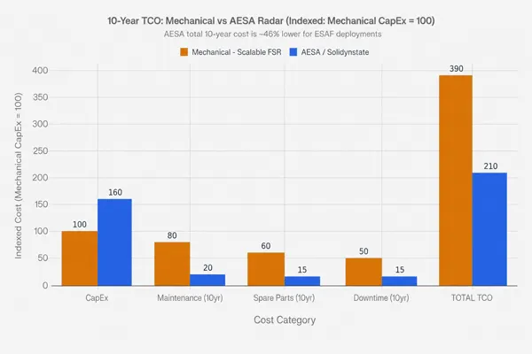
10-Year Cost Comparison (Indexed: Mechanical CapEx = 100)
| Cost Category |
Mechanical Scan |
AESA Radar |
Notes |
| Purchase (CapEx) |
100 |
160 |
AESA typically 1.3–1.6× mechanical |
| Annual Maintenance |
80 |
20 |
Mechanical requires rotating mechanism service |
| Spare Parts (10yr) |
60 |
15 |
Mechanical: motors, bearings, encoders |
| Downtime Cost (10yr) |
50 |
15 |
Mechanical MTBF ~12,000 h; AESA >65,000 h |
| Total 10-Year TCO |
390 |
210 |
AESA ~46% lower TCO for 24/7 deployments |
TCO model inputs for your site:
· Operational hours/year (24/7 = 8,760 h)
· Maintenance labor cost/hour in your region
· Required system availability (% uptime SLA)
· MTBF stated by supplier (request verification)
· Spare parts lead time in your deployment region
How to Compare Suppliers
Sensor Capability Matrix
| Capability |
Low-Alt UAV Radar |
Ground Radar |
RF Detection |
EO/IR Camera |
| Drone detection |
⭐⭐⭐⭐⭐ |
⭐ |
⭐⭐⭐ |
⭐⭐ |
| RF-silent drone |
✅ |
✅ (large) |
❌ |
✅ (short) |
| Bird discrimination |
AI ≥95% |
N/A |
N/A |
AI-based |
| Swarm (3+ objects) |
✅ |
❌ |
❌ |
❌ |
| All-weather |
✅ |
✅ |
✅ |
⚠️ |
| Night operation |
✅ |
✅ |
✅ |
Thermal only |
| Person detection |
❌ |
✅ 2–15 km |
❌ |
✅ limited |
| Vehicle detection |
❌ |
✅ 5–25 km |
❌ |
✅ limited |
| Vessel detection |
❌ |
✅ 5–50 km |
❌ |
✅ limited |
| Identity confirmation |
❌ |
❌ |
⭐⭐ |
✅ |
Supplier Scorecard (Editable — weight each dimension 1–3×)
| Evaluation Dimension |
Peso |
Supplier A |
Supplier B |
Supplier C |
| Detection range (RCS 0.01 m²) |
3× |
/10 |
/10 |
/10 |
| False alarm rate (field data) |
3× |
/10 |
/10 |
/10 |
| Track update rate |
2× |
/10 |
/10 |
/10 |
| Slew-to-cue performance |
2× |
/10 |
/10 |
/10 |
| RF-silent detection |
2× |
/10 |
/10 |
/10 |
| Integration (API/SDK) |
2× |
/10 |
/10 |
/10 |
| Certifications |
1× |
/10 |
/10 |
/10 |
| Multi-geography references |
2× |
/10 |
/10 |
/10 |
| Algorithm update frequency |
2× |
/10 |
/10 |
/10 |
| 10-year TCO estimate |
3× |
/10 |
/10 |
/10 |
| Support response time |
1× |
/10 |
/10 |
/10 |
| Field trial score |
3× |
/10 |
/10 |
/10 |
| Weighted Total |
|
|
|
|
Procurement Journey & Process
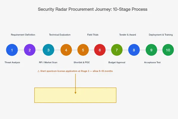
PHASE 1 — REQUIREMENTS
Threat Analysis → Environment Assessment → Budget Planning → Coverage Geometry
↓
PHASE 2 — MARKET ENGAGEMENT
Issue RFI → Collect Technical Responses → Shortlist 3–5
⚠️ START SPECTRUM LICENSING HERE
↓
PHASE 3 — TECHNICAL EVALUATION
Datasheet Review → Reference Site Visits → API Documentation Check
↓
PHASE 4 — FIELD TRIALS
9 Standard Scenarios · Score per Matrix
False Alarm Measurement ≥ 72 hours in target environment
↓
PHASE 5 — COMMERCIAL EVALUATION
10-Year TCO Analysis · SLA Negotiation
Acceptance Test Criteria Defined Before Contract
↓
PHASE 6 — DEPLOYMENT
Site Survey + Coverage Planning + Installation
Calibration + Operator Training + Acceptance Test
↓
PHASE 7 — LIFECYCLE MANAGEMENT
Algorithm Updates · Quarterly Performance Reviews
Threat Intelligence Integration · Expansion Planning
Case Studies: Five Vertical Applications
Case Study 1: International Airport — Drone Detection & Airspace Monitoring
Challenge: A major international airport with over 60 million annual passengers experienced a 300% increase in unauthorized drone incursions over 18 months. Existing RF monitoring only detected 60% of incidents; pre-programmed RF-silent drones were invisible. Operations were disrupted on 31 occasions in a single year.
Solution: Four A-Series AESA radar panels providing 360° coverage to 8 km, integrated with RF spectrum monitoring and PTZ thermal imaging cameras. ASTERIX Cat 240 interface completed PSIM integration in 11 days.
Outcome: Detection coverage increased to 98% including RF-silent objects. False alarm rate reduced to < 3/day. Runway disruption incidents reduced by 89% in the first 12 months.
Key Specification: A-Series AESA · 8 km at RCS 0.01 m² · < 3 false alarms/day · Slew-to-cue < 4 s
Case Study 2: National Land Border — Perimeter Monitoring
Challenge: A 380 km land border section required 24/7 monitoring for ground crossings, vehicle incursions, and drone-based package deliveries. The environment spans desert plains, river crossings, and dense scrubland at −25°C to +52°C.
Solution: G-Series radars (MR-RDG20K) at 18 km spacing for personnel/vehicle detection, T-Series at high-incident points for drone detection, all feeding a centralized C2 platform with GIS overlay.
Outcome: Average response time reduced from 42 minutes to 8 minutes. Personnel detection rate at 10 km exceeded 94%.
Case Study 3: Port & Maritime Facility — Multi-Threat Monitoring
Challenge: A container port handling 8 million TEU annually required simultaneous monitoring for vessel approach, perimeter intrusion, and drone activity over cargo areas.
Solution: G-Series (MR-RDG50K) for vessel detection to 50 km and ground coverage to 25 km, integrated with T-Series for drone detection and Radar-Vision Fusion at perimeter posts.
Outcome: Vessel response time improved from 18 minutes to < 2 minutes. Ground intrusion detection increased from 67% to 97%.
Case Study 4: Oil & Gas Offshore/Onshore Facility
Challenge: Combined threat: unauthorized drone surveillance of platform topside plus vessel approach to the exclusion zone, in a high sea clutter / salt spray / 24/7-critical environment.
Solution: G-Series with sea clutter CFAR for vessel detection to 30 km, A-Series AESA for drone detection, IP67-sealed with heated enclosures, integrated with facility DCS/SCADA.
Outcome: Two unauthorized drone approaches detected in the first 90 days, including one RF-silent pre-programmed object.
Case Study 5: Major Public Event — Temporary Deployment
Challenge: Multi-day international event, 120,000 daily spectators, no permanent infrastructure, 48-hour setup window, zero tolerance for false alarms that could trigger public evacuation.
Solution: Portable T-Series radar at four venue perimeter points, RF monitoring, PTZ thermal cameras, all networked to a mobile command vehicle. AI classification threshold tuned to urban environment in 24-hour pre-event calibration.
Outcome: False alarm rate: 0/day throughout the event. Full system deployed and calibrated in 31 hours.
ROI Framework for Drone Detection Investment
ROI Category 1: Incident Cost Avoidance
| Incident Type |
Average Cost per Event |
Incidents Avoided Annually |
Annual Value |
| Airport runway hold |
$150K–$500K |
25–40/year |
$3.75M–$20M |
| Port cargo theft investigation |
$50K–$200K |
8–15/year |
$400K–$3M |
| Critical infrastructure inspection trigger |
$20K–$80K |
15–30/year |
$300K–$2.4M |
ROI Category 2: Operational Efficiency
| Articolo |
Manual Patrol Model |
Radar Model |
Annual Saving |
| Security patrol staff (perimeter) |
12–20 FTE × $60K |
3–5 FTE monitoring |
$540K–$900K |
| CCTV monitoring staff |
4–8 FTE |
1–2 FTE |
$180K–$360K |
Simple Payback Model (Airport Example)
· AESA system cost: $800K–$1.2M all-in
· 12 runway holds/year avoided at avg $250K each = $3M/year avoidance value
· Simple payback: 3–5 months
Complete Evaluation Checklist
Technical Performance
· Detection range at RCS 0.01 m² (UAV) — not unqualified range
· Detection range at RCS 0.005 m² for high-security sites
· Track update rate ≥ 0.25 s (AESA TAS) or ≥ 2 s (mechanical)
· Range accuracy ≤ 5 m RMS; angular accuracy ≤ 0.5° RMS
· Velocity accuracy ≤ 0.5 m/s
· Track capacity matches expected object density
· False alarm rate ≤ 5/hour (staffed) or ≤ 1/day (automated)
· Micro-Doppler classification accuracy ≥ 90%
· RF-silent detection demonstrated with field (not lab) data
Architettura del sistema
· Multi-sensor fusion available (radar + RF + EO/IR)
· Slew-to-cue < 5 seconds; target in frame without manual search
· Deployment flexibility: fixed + vehicle-mounted + portable
· AESA graceful degradation or mechanical MTBF stated
Integration
· API/SDK documentation provided before contract
· GB/T 28181 / ONVIF / RTSP / RESTful API confirmed
· SAPIENT ICD confirmed (government deployments)
· ASTERIX Cat 240/48 confirmed (airport deployments)
· Multi-site centralized monitoring confirmed
Certifications
· CE (RED) / FCC / UKCA per deployment region
· ISO 9001; ISO 14001; ISO 45001
· IP66 / IP67; operating temperature covers environment
· Spectrum license application process confirmed
Qualifica del Fornitore
· Deployments in comparable environments verified
· Reference site in your region contactable
· Core components in-house (TR modules, algorithms, C2)
· Algorithm update frequency documented
· 24/7 remote support confirmed
Commercial
·10-year TCO analysis completed
· Acceptance test criteria defined before contract
·Software update obligations in contract terms
· Export control classification confirmed
Glossary
AESA: Active Electronically Scanned Array. Solid-state radar antenna with per-element transmit/receive modules — no moving parts.
ASTERIX: Eurocontrol standard data format for ATM radar data exchange. Cat 240 for radar video; Cat 48 for target reports.
CFAR: Constant False Alarm Rate. Detection threshold algorithm that adapts to maintain constant false alarm probability.
DBF: Digital Beamforming. Digital signal processing enabling simultaneous beams at multiple elevation angles.
FMCW: Frequency Modulated Continuous Wave. Radar waveform providing simultaneous range and velocity measurement.
GMTI: Ground Moving Target Indication. Detects and tracks ground-moving targets by Doppler filtering of stationary clutter.
IP66 / IP67: Ingress Protection ratings. IP66: dust-tight + high-pressure water jet. IP67: dust-tight + 1 m temporary immersion.
Micro-Doppler: Frequency modulations from rotating/oscillating sub-components. Drone propellers and bird wings produce distinct patterns enabling AI classification.
MTBF: Mean Time Between Failures. Mechanical scan: 8,000–15,000 h typical. AESA: typically > 65,000 h.
RCS: Radar Cross Section. Measure in m² of how effectively a target reflects radar energy. DJI Phantom 4 ≈ 0.01 m².
SAPIENT: Sensing for Asset Protection with Integrated Electronic Networked Technology. Open interface standard for drone detection system interoperability.
Slew-to-Cue: Automated process directing a PTZ camera to the position of a radar-detected object. Performance: < 5 seconds.
TAS (Track-After-Scan): AESA mode providing dedicated beam dwell time to confirmed tracks, achieving 0.25 s update rate.
TCO: Total Cost of Ownership. CapEx + OpEx over defined lifecycle period.
TWS (Track-While-Scan): Radar mode maintaining tracks while simultaneously scanning for new detections.
Domande Frequenti
Q1: How far can a drone detection radar detect a DJI drone?
DJI Phantom 4 (RCS ≈ 0.01 m²): approximately 3–10 km for T-Series mechanical scan, and 5–8 km for A-Series AESA. In urban or coastal conditions, effective range is 30–50% lower than free-space figures.
Q2: What RCS value should I use in my procurement specification?
Use RCS = 0.01 m² as the primary benchmark. Add RCS = 0.005 m² for high-security sites expecting custom or carbon-fiber objects.
Q3: Why does track refresh rate matter for drone detection?
At 2-second update rate, an object at 20 m/s moves 40 m between updates — likely outside PTZ FOV. At 0.25 s TAS, it moves 5 m — reliably within frame.
Q4: What is the difference between TWS and TAS?
Track-While-Scan updates all objects at the scan rate. Track-After-Scan (AESA only) provides dedicated beam time to confirmed objects at 0.25 s while maintaining full-volume TWS simultaneously.
Q5: What certifications should a drone detection radar supplier have?
At minimum: CE (RED) for EU; ISO 9001; IP66 or IP67. Airport deployments additionally require spectrum clearance and ASTERIX compatibility.
Q6: What is slew-to-cue and why does it matter operationally?
Slew-to-cue automatically directs a PTZ camera to a radar-detected object. A well-calibrated system achieves this in < 5 seconds. Failure requires operators to manually search, significantly increasing response time.
Q7: How should airports procure drone detection radar?
Key requirements: spectrum coordination with national aviation authority (6–18 months), ASTERIX Cat 240/48 compatibility, ILS/DME/ATCRBS interference clearance, and FAA Cert Alert 21-04 / ICAO Doc 10019 alignment.
Q8: How do I compare AESA and mechanical scan radar?
AESA: higher CapEx, no moving parts, MTBF > 65,000 h, 0.25 s TAS update, lower 10-year TCO for 24/7. Mechanical: lower CapEx, periodic maintenance, 2–3 s scan update, highest coverage per CapEx dollar.
Q9: Can drone detection radar distinguish birds from drones?
Yes — using micro-Doppler analysis. Birds produce 3–15 Hz oscillating modulation from wing-flapping; drone propellers produce higher-frequency (50–200 Hz) mechanically regular modulation. AI achieves > 95% discrimination in field conditions.
Q10: What is the difference between RF detection and radar?
RF detection monitors control link emissions — effective for standard RC-protocol drones, completely blind to RF-silent pre-programmed drones. Radar detects any target regardless of RF emission.
Q11: How many simultaneous objects must a drone detection radar track?
Single-site: 50–200. Airport/border: 500+. Swarm scenarios: 1,000–2,000+.
Q12: What should be included in a drone radar acceptance test?
Minimum: detection of reference object at specified RCS/ranges; track continuity (60 s hover, no drop); slew-to-cue timing; false alarm measurement (≥ 72 hours in real environment); RF-silent detection; multi-object capacity test.
Q13: How do I calculate a practical false alarm rate budget?
A single operator can investigate approximately 5–10 alarms/hour before fatigue-induced degradation. Set requirement from staffing model: < 5/hour for single-operator; < 1/hour for part-time; < 1/day for automated-response.
Q14: What open standards should a drone detection radar support?
GB/T 28181 (China IP camera standard), ONVIF Profile S/T, RTSP, RESTful API, ASTERIX Cat 240/48 (airport), SAPIENT ICD (multi-vendor government). Request documentation for each before procurement.
Q15: What are the key differences between airport and critical infrastructure drone detection?
Airports require spectrum-cleared equipment, ATM integration, and navigation aid deconfliction — plus regulatory pre-approval in many jurisdictions. Critical infrastructure prioritizes all-weather reliability, long perimeter coverage, multi-threat detection (drone + ground), and SCADA/DCS/PSIM integration.
Domande Frequenti
How far can a drone detection radar detect a DJI drone?
DJI Phantom 4 (RCS ≈ 0.01 m²): approximately 3–10 km for T-Series mechanical scan, and 5–8 km for A-Series AESA. In urban or coastal conditions, effective range is 30–50% lower than free-space figures.



 14:40
14:40