Executive Summary
Selecting the appropriate radar frequency band is one of the most important decisions when designing a low-altitude airspace security system. Choosing the wrong technology can result in reduced detection performance, excessive false alarms, operational blind spots, and significantly higher lifecycle costs.
Among the radar technologies used for drone detection, X-band and Ku-band are the most widely deployed. While both can detect and track unmanned aerial vehicles (UAVs), they are optimized for fundamentally different missions.
X-band radar (8-12 GHz) is designed for long-range surveillance, wide-area monitoring, and early warning applications. Commonly deployed at airports, border regions, and large-scale critical infrastructure.
Ku-band radar (12-18 GHz) is optimized for detecting and tracking small, low-RCS targets such as consumer drones, FPV drones, and commercial UAVs operating at low altitude.
For most professional counter-UAV deployments, the best solution is not choosing one band over the other. A layered architecture combining X-band radar, Ku-band radar, EO/IR sensors, and command-and-control software delivers the highest level of situational awareness and operational effectiveness.
This guide is intended for airport security managers, border protection agencies, critical infrastructure operators, public safety organizations, and system integrators evaluating radar technologies for drone detection and low-altitude airspace security.
This guide was developed by the Midradar technical team, drawing on radar deployment projects across airports, border corridors, energy facilities, and urban security programs in 50+ countries. Midradar designs and manufactures X-band and Ku-band radar systems available for international procurement. Detection range versus RCS performance data for all standard configurations is available on request.
Technical Comparison Matrix
| Parameter |
X-Band Radar |
Ku-Band Radar |
| Frequency Range |
8-12 GHz |
12-18 GHz |
| Wellenlänge |
2.5-3.75 cm |
1.67-2.5 cm |
| Typical Detection Range |
15-30+ km |
3-15 km |
| Small Drone Detection (RCS < 0.01 m2) |
Good |
Excellent |
| Angular Resolution |
Good |
Excellent |
| Micro-Doppler Performance |
Good |
Excellent |
| False Alarm Rate (Cluttered Env.) |
Moderate |
Low |
| Long-Range Early Warning |
Excellent |
Begrenzt |
| Heavy Rain Performance |
Excellent |
Good |
| Urban Environment Performance |
Good |
Excellent |
| Typische Anwendungen |
Airports, Borders, Energy Infrastructure |
Critical Infrastructure, Urban, Counter-UAV |
False Alarm Note: In high-clutter environments, operator workload is often driven more by nuisance alarms than by raw detection range. Ku-band generally provides better target-clutter discrimination and lower false alarm rates when tracking small drones in urban settings.
Midradar offers both X-band and Ku-band configurations. Compare systems at midradar.com/products/
X-Band- vs. Ku-Band-Radar zur Drohnenerkennung: Für welches sollten Sie sich entscheiden?
Procurement Decision Tree
| Need detection beyond 15 km?
|
+– Yes –> X-Band Radar
|
+– No
|
+– Primary threat: small consumer drones?
| |
| +– Yes –> Ku-Band Radar
| +– No
| |
| +– Airport or port security?
| | –> X-Band + Ku-Band [View: midradar.com/products/]
| +– Energy or urban facility?
| –> Ku-Band + EO/IR
|
+– Need all-weather + wide coverage?
–> X-Band + Ku-Band + EO/IR |
Key Takeaways for Procurement
| Operational Requirement |
Recommended Solution |
| Long-range early warning (>15 km) |
X-Band |
| Small drone detection (RCS < 0.03 m2) |
Ku-Band |
| Airport perimeter and approach surveillance |
X-Band + Ku-Band |
| Border and coastal monitoring |
X-Band |
| Energy facility protection |
Ku-Band |
| Urban public safety operations |
Ku-Band |
| High-clutter environments |
Ku-Band |
| Full-spectrum low-altitude airspace defense |
X-Band + Ku-Band + EO/IR |
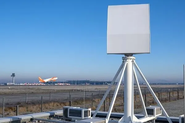
Understanding X-Band Radar
Operating between 8 GHz and 12 GHz, X-band radar has served as a foundational technology for aviation security, maritime monitoring, border protection, and large-area surveillance for decades. Its longer wavelength allows energy to propagate efficiently over long distances while maintaining reliable performance under adverse weather conditions.
Long-Range Detection Capability
X-band radar excels at wide-area surveillance. Typical deployment environments:
• Airport perimeter and approach zone monitoring
• National border surveillance corridors
• Coastal and port security
• Large-scale energy and industrial facility protection
• Nationwide critical infrastructure monitoring
Depending on radar architecture and target characteristics, detection ranges routinely exceed 20-30 kilometers against medium-to-large aerial targets.
Extended Reaction Time
Long-range detection provides security operators with time to assess threats, coordinate response assets, and implement protective measures before a threat reaches its objective. For many deployments, reaction time is operationally more valuable than maximum detection range.
All-Weather Reliability
Compared with higher-frequency radar bands, X-band experiences lower atmospheric attenuation, enabling reliable operation in heavy rain, dense fog, snow, and dust. This makes X-band the preferred technology for persistent 24/7 airspace monitoring in challenging climatic environments.
Cost-Effective Area Coverage
A single X-band radar installation can monitor airspace sectors spanning hundreds of square kilometers, making it cost-efficient for national infrastructure projects and large facility perimeter security.
Limitations of X-Band Radar
• Reduced sensitivity to micro-drones and low-RCS consumer UAVs
• Lower angular resolution compared with Ku-band systems
• Susceptibility to clutter in complex terrain without advanced signal processing
• Less effective target separation in dense urban environments
Understanding Ku-Band Radar
Ku-band radar operates between 12 GHz and 18 GHz and has become one of the most widely adopted technologies for dedicated counter-UAV and low-altitude security systems. Its shorter wavelength significantly improves detection sensitivity against small aerial targets.
Superior Small-Drone Detection
Ku-band radar is highly effective against consumer quadcopters, FPV drones, commercial UAVs, and other low-RCS aerial threats. The shorter wavelength creates stronger electromagnetic interactions with small drone structures, improving minimum detectable signal thresholds and overall detection reliability.
Higher Angular Resolution
Compared with X-band radar, Ku-band systems provide tighter beam widths, resulting in:
• Better target separation in dense airspace
• Improved altitude estimation
• Enhanced multi-target tracking
• More accurate sensor cueing for EO/IR verification systems
Advanced Micro-Doppler Analysis
Rotating drone propellers generate distinctive micro-Doppler frequency signatures. Modern Ku-band radar processors analyze these to distinguish drones from birds, weather phenomena, and environmental clutter, directly reducing nuisance alarms during sustained operations.
Lower False Alarm Rates in Urban Environments
Ku-band radar’s superior resolution enables finer clutter discrimination in urban and suburban deployments, reducing false detections and improving operator confidence in high-density environments.
Limitations of Ku-Band Radar
• Shorter maximum detection range limits utility for wide-area early warning
• Greater atmospheric attenuation in heavy precipitation compared with X-band
• Typically higher unit cost per kilometer of coverage
• Spectrum licensing requirements vary by jurisdiction
Radar Cross Section (RCS) and Small Drone Detection
Radar Cross Section (RCS) is the parameter that most directly determines how detectable a target is. Smaller RCS values indicate harder-to-detect targets. Most consumer and commercial drones fall in the low-RCS category that challenges conventional radar systems.
Indicative RCS Ranges by Target Category
| Target Category |
Approximate RCS Range |
| Commercial Airliner |
100-1,000 m2 |
| Light Aircraft |
1-10 m2 |
| Helicopter |
1-5 m2 |
| Large Commercial UAV |
0.1-1 m2 |
| Consumer Multirotor Drone |
0.003-0.05 m2 |
| Micro UAV / FPV Drone |
0.001-0.01 m2 |
Important: Actual RCS values vary significantly depending on target orientation, operating frequency, payload configuration, aspect angle, and measurement methodology. These figures are indicative planning references. Independent field verification under representative deployment conditions is recommended before finalizing system procurement.
When evaluating radar vendors, request detection performance curves showing range versus RCS across the relevant target spectrum for your deployment scenario.
Three Procurement Mistakes to Avoid

Mistake #1: Comparing Detection Range Without RCS Context
A radar system advertised as detecting targets at 30 km may achieve that range only against large aircraft. Against a consumer drone with an RCS of 0.01 m2, the same system may provide reliable detection only to 3-5 km.
Always ask vendors: What target RCS was used to calculate the published detection range? Can you provide a detection range versus RCS performance curve for our threat profile? Reputable manufacturers provide this data as standard.
Mistake #2: Ignoring Site-Specific Environmental Conditions
Radar performance is highly environment-dependent. Terrain profile, proximity to buildings and vehicle traffic, local weather patterns, and electromagnetic interference all affect real-world system performance. A radar optimized for open-terrain border surveillance may generate unacceptable false alarm rates at an urban energy facility. Request site-specific performance modeling or a field trial before committing to procurement.
Mistake #3: Treating Radar as a Standalone Solution
Radar detects and tracks aerial objects. It does not reliably identify them. Professional low-altitude security systems integrate:
• Radar detection (X-band and/or Ku-band)
• EO cameras for visual identification
• Thermal imaging for night and adverse-weather confirmation
• RF spectrum analyzers for communications protocol identification
• AI classification software for automated alert filtering
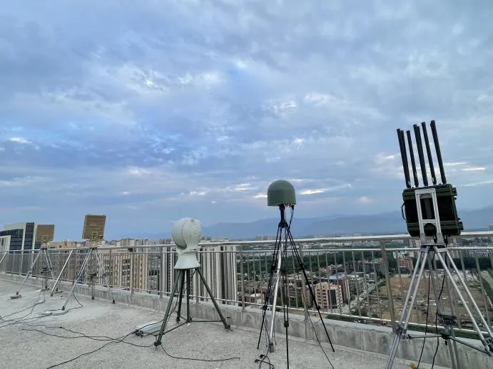
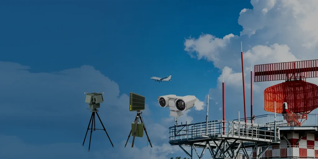
Multi-Sensor Fusion Architecture
Professional drone detection deployments rarely rely on a single sensor technology. A layered architecture distributes responsibilities across detection, verification, classification, and command functions.
Detection Layer
• X-band radar for wide-area early warning at extended range
• Ku-band radar for precision small-UAV detection and tracking
Verification Layer
• EO cameras for daylight visual confirmation
• Thermal cameras for night and low-visibility identification
Classification Layer
• AI target recognition and alert filtering software
• RF signal analysis for UAV protocol identification
• Micro-Doppler spectral processing for target type classification
Command and Control Layer
• GIS-based airspace situational display
• Integrated alert management and operator workflow
• Incident logging and evidence capture
• Sensor fusion and track correlation
This architecture improves detection reliability, reduces nuisance alarms, and provides the operational and evidentiary record required for response coordination and post-incident review.
Deployment Recommendations by Scenario
Airport and Aviation Facility Security
Threat Profile
• Unauthorized consumer drones within approach and departure corridors
• FPV drones with rapid maneuver capability
• Potential coordinated multi-drone operations during peak traffic periods
Key Performance Requirements
• Minimum detectable RCS: 0.01 m2 at 3-5 km
• Track update rate: <=2 seconds for active targets
• Simultaneous track capacity: 50+ targets
• False alarm rate: operationally manageable without dedicated filtering staff
Recommended Architecture
• X-band radar for outer perimeter early warning at 10-20 km
• Ku-band radar for precision tracking within the 5 km critical approach zone
• EO/IR camera system slaved to radar track output for target verification
• Integrated command platform for multi-sensor display and alert management
Recommended Midradar configuration: MR-RDT20K (outer X-band perimeter) + MR-RDT05K (inner Ku-band precision tracking)
Integration Note: Coordination with existing aviation navigation and communications systems is required. Approval from the national civil aviation authority is typically required before operational deployment.
Border and Coastal Monitoring
Threat Profile
• Cross-border drone operations for smuggling, reconnaissance, and communications relay
• Threats typically operating at low altitude to reduce radar signature
• Entry corridors may span hundreds of kilometers of mixed terrain
Key Performance Requirements
• Detection range: 15-30 km against medium-sized UAVs
• Persistent 24/7 all-weather coverage
• Low false alarm rate against birds and terrain features
Recommended Architecture
• Long-range X-band radar deployed in overlapping coverage sectors
• Thermal imaging systems for medium-range verification
• Integration with border command platforms for multi-agency coordination
Energy and Industrial Facility Protection
Threat Profile
• Targeted drone operations against power generation, oil and gas, and water treatment facilities
• Threats: small consumer or modified commercial drones at 1-5 km range
• Payload delivery and reconnaissance are the primary threat vectors
Key Performance Requirements
• Minimum detectable RCS: 0.003-0.01 m2 at 1-3 km
• High angular resolution for precise approach trajectory analysis
• Low false alarm rate in industrial clutter environments
Recommended Architecture
• Ku-band radar as the primary detection sensor within the 5 km threat envelope
• AI-enabled classification to reduce false alarms from birds and industrial equipment
• EO/IR verification optimized for identification at 1-3 km
• Command platform integrated with facility security operations center
Urban Public Safety and Event Security
Threat Profile
• Unauthorized drone overflights of public spaces, government buildings, and transportation hubs
• Primary concerns: privacy violations, payload delivery, airspace disruption
Key Performance Requirements
• Detection in dense clutter with high false alarm rejection
• Minimum detectable RCS: 0.01 m2 at 1-3 km
• Rapid alert and track handoff to verification sensors
Recommended Architecture
• Ku-band radar for precision small-drone detection in cluttered urban airspace
• EO/IR cameras for rapid target identification
• AI analytics for automated threat classification and alert prioritization
Port and Maritime Facility Security
Threat Profile
• Drone-based reconnaissance of vessel movements and cargo operations
• Potential smuggling operations using drones to transfer contraband
• Threats may approach from both land-side and sea-side directions
Recommended Architecture
• X-band radar for maritime surface and air surveillance at extended range
• Ku-band radar for precision tracking within the inner port security zone
• Thermal imaging for low-visibility target verification
Estimated Radar Architecture by Facility Type
| Facility Type |
Recommended Architecture |
| Small Commercial Facility |
Single Ku-Band Radar + EO/IR |
| Industrial Campus |
Ku-Band + EO/IR + AI Analytics |
| Oil and Gas Refinery |
Ku-Band + EO/IR + AI Analytics |
| International Airport |
X-Band + Ku-Band + EO/IR |
| Border Surveillance Corridor |
X-Band + Thermal Cameras |
| Port or Maritime Facility |
X-Band + Ku-Band + Thermal |
| National Critical Infrastructure |
X-Band + Ku-Band + EO/IR + Command Platform |
Regulatory and Spectrum Considerations
Radar procurement for drone detection involves both technical and regulatory dimensions that must be addressed during the planning phase. Regulatory issues identified late in the procurement cycle are among the most common causes of project delay and cost overrun.
Spectrum Licensing
Both X-band and Ku-band frequencies fall within regulated spectrum bands in most jurisdictions. Operation of ground-based radar systems typically requires authorization from the national telecommunications regulatory authority. Licensing timelines vary from several weeks to several months – budget adequate time during project planning.
Elektromagnetische Verträglichkeit
Airport and port deployments typically require formal electromagnetic compatibility (EMC) analysis to confirm that radar operation will not interfere with navigation aids, vessel traffic systems, or other critical electronics. This is conducted by the facility operator with technical support from the radar manufacturer.
Export Compliance
Radar systems for border security, critical infrastructure protection, and counter-UAV applications are typically classified as dual-use goods. Exports from China are governed by the Export Control Law and the Dual-Use Items Export Control List (MOFCOM Notice No. 51, 2024). Importers should verify that the supplier has completed applicable export classification procedures and can provide compliance documentation prior to shipment.
Procurement Recommendation
Engage compliance specialists and the radar manufacturer’s export team at the earliest stage of project planning. For international deployments, allow a minimum of 60-90 days for export documentation, import licensing, and spectrum authorization processes to be completed in parallel with technical procurement activities.
Frequently Asked Questions
Is Ku-band radar better than X-band for drone detection?
For small consumer drones, Ku-band generally provides better detection sensitivity, tracking precision, and clutter suppression. However, for wide-area surveillance where the priority is detecting threats at 15-30 km, X-band remains the more appropriate primary technology. Most professional counter-UAV architectures use Ku-band for precision detection within the inner threat zone and X-band for outer perimeter early warning. The two technologies are complementary rather than competitive.
Can X-band radar detect DJI and similar consumer drones?
Yes. Against consumer multirotor drones with RCS values typically in the range of 0.01-0.05 m2, capable X-band systems generally achieve reliable detection at 3-8 km. Ku-band systems typically extend reliable detection range against the same targets to 5-12 km. When evaluating radar systems, request detection range versus RCS performance data rather than relying on maximum range headline specifications.
Which radar band performs better in heavy rain?
X-band radar generally maintains better performance during heavy rainfall. In heavy rainfall conditions above approximately 10-15 mm per hour, Ku-band radar detection range can be reduced by 15-30% compared with dry-weather performance. For deployments in tropical, monsoon, or coastal climatic zones, X-band radar should form the primary all-weather detection layer.
Do airports use both X-band and Ku-band radar?
Advanced airport drone detection deployments increasingly combine both technologies. X-band provides early warning at extended range across the airport perimeter, while Ku-band provides high-precision tracking and classification within the critical inner zone near runways. Single-sensor airport deployments are increasingly considered inadequate under current low-altitude threat assessments.
What detection range should I expect against a consumer-sized drone?
For consumer multirotor drones with RCS values typically below 0.05 m2, professional drone detection radar systems generally achieve reliable detection ranges of 3-12 km depending on system type and environmental conditions. Procurement decisions should be based on verified field-testing data under representative site conditions rather than vendor-published maximum range figures.
How many targets can one radar track simultaneously?
Track capacity varies significantly by radar design. Entry-level systems typically support 20-50 simultaneous tracks. Systems for larger facilities commonly support 100-200 tracks. Advanced phased-array systems can maintain 500+ simultaneous tracks. Requirements should be specified based on peak scenario load rather than average conditions.
What radar systems does Midradar offer for drone detection?
Midradar manufactures both X-band and Ku-band radar systems for low-altitude surveillance and counter-UAV applications. X-band configurations support detection ranges from 10 to 20 km. Ku-band configurations provide precision tracking of targets with RCS as low as 0.001 m2. All systems support 360-degree azimuth coverage and integrate with EO/IR verification sensors and command software. Full product specifications: midradar.com/products/
Can Midradar provide a site-specific coverage analysis before procurement?
Yes. Midradar’s technical team conducts coverage modeling based on facility terrain, threat profile, and operational requirements before system recommendation. This includes detection range mapping, blind zone analysis, and multi-sensor integration planning. Contact the technical team at midradar.com/contact/ to initiate a coverage analysis for your project.
Fazit
There is no universally superior radar frequency band for drone detection. The right technology depends on operational requirements, threat profile, terrain, and environmental conditions.
Choose X-Band Radar When:
• Long-range surveillance is the priority (15-30+ km)
• Large geographic areas must be covered with limited sensor nodes
• All-weather operational persistence is a primary requirement
• Early warning reaction time is operationally critical
Choose Ku-Band Radar When:
• Small consumer drone detection is the primary mission
• Urban, suburban, or industrial deployment with complex clutter
• Low false alarm rates are a priority
• High tracking precision and EO/IR sensor cueing are required
Choose a Combined Architecture When:
• The deployment must address the full aerial threat spectrum
• Airport, port, border, or national critical infrastructure protection is the mission
• Operational continuity under adverse weather is required
• The highest level of airspace situational awareness is the objective
For most professional low-altitude security projects, a layered architecture combining X-band radar, Ku-band radar, EO/IR sensors, AI analytics, and an integrated command platform delivers the operational effectiveness that single-technology deployments cannot achieve.