How to Choose a Low-Altitude Surveillance Radar: 1 km, 5 km and Long-Range Coverage Explained
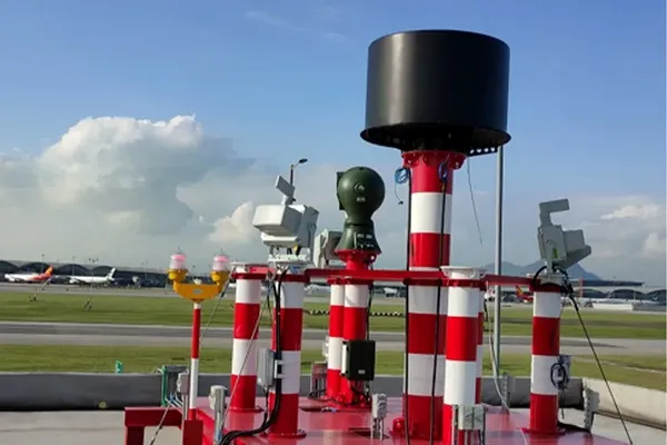
Selecting a low-altitude surveillance radar is not simply a matter of choosing the longest stated detection range. A radar designed for 5 km coverage may be suitable for airports, industrial facilities, logistics hubs, or wide-area sites, while a 1 km radar may be more practical for compact facilities, rooftops, local perimeters, and focused observation zones.
The right system depends on the size of the monitored area, the types of low-altitude objects to be observed, site geometry, environmental conditions, and whether the radar should work with visible-light or thermal cameras for visual verification.
For most professional projects, the selection process should begin with a simple question:
What coverage, verification, and operational awareness does the site actually require?
This guide explains how to evaluate 1 km, 5 km, and long-range radar systems for low-altitude monitoring, site awareness, airport operations, industrial facilities, and multi-sensor surveillance projects.
Midradar has been developing surveillance radar and sensor fusion technology since 2015, with systems deployed across more than 50 countries and over 1,000 installations spanning border security, airport, maritime, and industrial applications. Midradar’s radar systems are ISO 9001 and CE certified.
How to Choose a Low-Altitude Surveillance Radar?
Quick Answer: Which Radar Range Is Suitable?
| Monitoring Requirement |
Typical Site Type |
Recommended Configuration |
| Up to 1 km |
Warehouses, rooftops, local perimeters, small industrial sites, temporary sites |
Compact surveillance radar with PTZ or thermal-camera verification |
| 1–5 km |
Industrial parks, substations, ports, logistics hubs, larger campuses, small airports |
Medium-range radar with EO/IR integration and centralized alarm management |
| 5 km and beyond |
Airports, large industrial facilities, coastal sites, major energy facilities, wide-area projects |
Long-range surveillance radar with multi-sensor integration |
| Complex sites with obstructions |
Sites with buildings, tanks, trees, cranes, terrain changes, or multiple zones |
Long-range radar for broad-area awareness plus short-range radar for local coverage |
These ranges describe typical project coverage tiers rather than fixed performance guarantees for every model, target type, or environment. See the product mapping table below for Midradar’s documented radar series and their published detection ranges.
For many projects, the best solution is not choosing between 1 km and 5 km. A layered architecture can combine longer-range radar for wide-area awareness with short-range radar and EO/IR sensors for close-in observation and visual verification.
For available radar categories and key product parameters, visit the Midradar Surveillance Radar Catalog.
What Is a Low-Altitude Surveillance Radar?
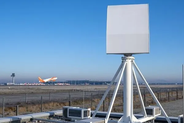
A low-altitude surveillance radar is a sensor designed to detect, locate, and track objects operating at relatively low altitude within a defined monitoring area. Depending on the radar type and system configuration, it can provide information such as target range, direction, speed, movement track, and position updates.
Low-altitude monitoring may be required at airports, industrial facilities, ports, logistics hubs, energy sites, large campuses, and other locations where operators need better awareness of activity above or around the site.
Unlike a conventional camera, radar can monitor a larger area continuously and can remain useful in low-light or changing weather conditions. In many projects, radar is combined with visible-light and thermal cameras to support visual verification.
Learn more about Sistemas de Fusión Radar-Visión for integrated radar, visible-light, thermal imaging, and automated camera-tracking workflows.
1 km, 5 km, or Long Range: The Core Difference
The correct coverage range depends on the size of the site, required reaction time, object characteristics, installation conditions, and the level of visual verification needed.
1 km Coverage: Local Monitoring and Close-In Awareness
A 1 km surveillance radar is often suitable when the monitored area is compact, the purpose is local awareness, or buildings and equipment limit long-distance line of sight.
Typical applications include:
● Warehouses and logistics facilities
● Industrial buildings and campuses
● Rooftops and urban sites
● Local perimeters
● Construction sites
● Temporary event sites
● Solar farms and utility installations
● Local waterfront facilities
● Focused monitoring around important equipment
A 1 km system may be mounted on a rooftop, local tower, pole, or dedicated mast. It can be combined with a PTZ camera to provide radar-guided visual verification of activity within the monitored sector.
5 km Coverage: Facility-Wide Monitoring
A 5 km surveillance radar is usually appropriate for medium-to-large facilities where operators need earlier visibility across a wider site area.
Typical applications include:
● Industrial parks
● Ports and logistics hubs
● Oil and gas facilities
● Power stations and renewable-energy sites
● Airports and heliports
● Large factories
● Coastal facilities
● Large campuses
● Wide-area construction projects
A 5 km configuration can provide broader awareness and give operators additional time to review radar tracks, camera feeds, and system alerts. It is typically best paired with long-range visible-light or thermal PTZ cameras for visual verification.
For projects requiring medium-range low-altitude monitoring, review the relevant Midradar Radar Systems and discuss site-specific coverage requirements with the technical team.
Long-Range Coverage: Wide-Area Operational Awareness
Long-range radar systems are typically considered when a site is very large, when broader low-altitude awareness is needed, or when site operators need to monitor activity across a wide surrounding area.
Typical applications include:
● Major airports and aviation facilities
● Large industrial and energy complexes
● Major ports and coastal sites
● Large logistics and transportation hubs
● Wide-area infrastructure projects
● Large environmental-monitoring areas
● Large public venues
● Regional operations centers
A long-range system should be selected only after reviewing actual site conditions. The radar must have a suitable installation location, practical line of sight, stable power and communications, environmental protection, maintenance access, and a clear monitoring workflow.
How to Choose a Low-Altitude Surveillance Radar?
Why Maximum Detection Range Is Not Enough?
A stated detection range should always be reviewed together with its test conditions. Real-world performance varies depending on the monitored object, installation environment, weather, terrain, and system settings.
Before comparing radar systems, ask these questions:
● What type of object was used for the stated range?
● What was the target radar cross section, or RCS?
● Was the target a small multirotor object, a fixed-wing platform, a bird, or another airborne object?
● At what altitude, speed, and approach direction was testing performed?
● Was the radar tested in open terrain, an industrial area, an urban site, or a coastal environment?
● Does the stated range refer to detection, continuous tracking, classification, or visual verification?
● What detection probability and false-alarm conditions apply?
A radar may observe a larger object at a significantly longer distance than a smaller one. Similarly, the same radar can perform differently when installed on an elevated mast with an open horizon compared with a site surrounded by buildings, tanks, cranes, trees, or uneven terrain.
A better procurement question is not “What is the maximum radar range?” but “What coverage can be expected for our intended object type and site conditions?”
For support with project-specific performance requirements, contact Midradar’s technical team.
Detection, Tracking and Visual Verification
A complete low-altitude monitoring system includes several functions. These functions should be assessed separately during project planning.
| Función |
What It Means |
Typical System Component |
| Detección |
Identifying that an object is present in the monitored area |
Surveillance radar |
| Seguimiento |
Calculating range, direction, speed, and movement over time |
Radar and monitoring platform |
| Classification |
Distinguishing likely object types based on movement or signal characteristics |
Radar processing and AI-assisted analysis |
| Visual Verification |
Reviewing the object through visible-light or thermal imagery |
EO/IR camera and PTZ system |
| Alarm Management |
Displaying tracks, video, alerts, and event records for operators |
Monitoring platform, VMS, or C2 system |
Radar is particularly useful for wide-area and continuous monitoring. EO/IR cameras can provide visual or thermal observation after the radar has identified a relevant area.
This is why many professional projects use Radar-EO/IR Integration radar provides track information, while visible-light and thermal imaging support verification, recording, and operator review.
How Radar and EO/IR Work Together?
Radar and EO/IR systems perform different but complementary tasks.
| System Component |
Primary Role |
Project Consideration |
| Surveillance Radar |
Wide-area detection, range, direction, speed, and track generation |
Requires suitable positioning and clutter management |
| Cámara de luz visible |
Daytime visual observation and documentation |
Depends on lighting, weather, and optical zoom |
| Cámara térmica |
Low-light and nighttime observation |
Depends on thermal contrast and lens selection |
| PTZ System |
Positions cameras toward an observation area |
Requires suitable speed and positioning accuracy |
| Monitoring Platform |
Displays radar tracks, camera video, alerts, and records |
Must support required system interfaces |
A radar-guided EO/IR workflow normally follows this process:
- The radar detects and tracks an object.
- The radar sends position and movement data to the monitoring platform.
- The platform calculates the relevant camera direction.
- The PTZ camera moves toward the observation area.
- Visible-light or thermal imaging supports visual verification.
- The system records the event and provides information for operator review.
The effectiveness of this process depends on radar accuracy, PTZ speed, camera optics, thermal capability, network latency, time synchronization, terrain, and software integration.
Explore Midradar’s Radar-Vision Fusion Systems for radar, visible-light, thermal imaging, AI-assisted tracking, and monitoring-platform integration.
Why Layered Coverage Often Works Better?
A single radar may not cover every part of a complex site. Buildings, tanks, trees, cranes, containers, fences, hills, and other structures can create shadow zones. Low-altitude objects may also move below the local horizon or close to structures.
A layered monitoring design may include: a wide-area monitoring layer (long-range radar for broader awareness), a visual verification layer (visible-light and thermal EO/IR cameras), a close-in monitoring layer (short-range radar for local zones and coverage gaps), and an operations layer (monitoring platform, alerts, video review, reporting, and records).
Example: Industrial Facility
A large industrial site may use:
- One 5 km radar for broad-area low-altitude monitoring
- One or more short-range radar units for loading areas, rooftops, tanks, or visually obstructed zones
- Long-range visible-light and thermal PTZ cameras for visual verification
- A monitoring platform for radar tracks, camera video, alert management, and historical records
- Integration with an existing VMS or site operations platform
This approach can improve coverage and operational visibility while avoiding the cost of placing long-range radar at every close-in monitoring point.
For projects involving facility-wide surveillance, review Midradar’s Radar Catalog y Radar-Vision Fusion Solutions.

How to Choose a Low-Altitude Surveillance Radar?
Factors That Affect Real Coverage
Object Size and Radar Cross Section
Radar cross section, or RCS, describes how detectable an object is to a radar. Object size, material, shape, orientation, movement, and attached equipment can influence radar return.
Small aerial objects may have a lower RCS than larger platforms. Procurement specifications should therefore define the intended object category rather than relying only on a general maximum-range statement.
Object Altitude
Objects operating at low altitude may be affected by buildings, trees, terrain, fencing, industrial equipment, and nearby infrastructure. Clear line of sight is essential for effective monitoring.
Radar Installation Height
Installing radar on a mast, tower, roof, or elevated structure may improve coverage. The final location should also consider wind load, vibration, lightning protection, maintenance access, cabling, power supply, and network connectivity.
Site Clutter
Industrial equipment, moving vehicles, cranes, birds, trees, fences, vessels, and nearby activity can create clutter. A suitable system should support practical clutter management, track processing, and configurable alarm rules.
Weather and Atmospheric Conditions
Rain, fog, dust, humidity, snow, and coastal conditions may affect sensors differently. Radar can support monitoring when visible-light imaging is limited, while EO/IR sensors provide complementary visual information when conditions allow.
Scan Method and Track Update Rate
Mechanical scanning, phased-array scanning, and electronically steered systems offer different trade-offs in coverage, revisit time, track continuity, complexity, and cost. The selected update rate should match the monitoring objective and expected object movement.
For technical guidance on radar categories, explore the Surveillance Radar Product Catalog.
1 km vs 5 km vs Long-Range Radar Comparison
| Requirement |
1 km Class |
5 km Class |
Long-Range Class |
| Typical coverage |
Compact facility or focused zone |
Large facility or broad site area |
Very large site or wide-area monitoring |
| Early operational awareness |
Limitado |
Moderate |
High |
| Installation complexity |
Low to medium |
Medium |
Medium to high |
| EO/IR verification value |
Recommended |
Strongly recommended |
Essential |
| Typical installation |
Rooftop, pole, local tower |
Elevated mast, building, site tower |
High tower or strategically elevated location |
| Best suited for |
Local observation |
Facility-wide monitoring |
Wide-area operational awareness |
Coverage Tier → Documented Midradar Product Line
| Coverage Tier |
Midradar Product Line |
Documented Detection Range |
Coverage Type |
| 1–5 km |
T-Series (Low-Altitude Surveillance Radar) |
50m – 20km* |
Acimut de 360 |
| 1–5 km |
A-Series (AESA Low-Altitude Radar) |
100m – 15km* |
Acimut de 360 |
| 5 km+ / long-range |
G-Series (Ground Surveillance Radar) |
50m – 50km* |
90° / 360° azimuth |
*Detection ranges vary by target radar cross section (RCS). Figures shown represent the documented range envelope across target types per Midradar’s published catalog, not a single fixed value. Confirm exact figures against the current product catalog before quoting a project.
Questions to Ask Before Requesting a Proposal
A detailed project brief makes it easier to select an appropriate system and compare proposals on real project requirements rather than headline specifications.
Site Information
- What is the monitored site?
- What total area needs to be covered?
- Is the site industrial, urban, coastal, open, mountainous, or heavily built-up?
- Are there buildings, trees, tanks, cranes, towers, or terrain features that may affect line of sight?
- Is 360-degree coverage required, or only a defined sector?
- What radar installation positions are available?
Monitoring Requirements
- What types of low-altitude objects should be observed?
- What are the expected size, speed, and operating altitude?
- Is the main objective site awareness, bird activity monitoring, operations support, or perimeter observation?
- Is continuous tracking required?
- Is visible-light or thermal verification required?
System Integration Requirements
- Is radar-guided PTZ camera movement required?
- Is a visible-light camera, thermal camera, or both required?
- Does the system need to connect to an existing VMS, security platform, or site-management platform?
- Is a centralized monitoring interface required?
- Is remote monitoring required?
- What power, network, and environmental constraints exist at the site?
Commercial and Documentation Requirements
- What is the destination country?
- Is this an active project, tender, distributor evaluation, or early-stage planning request?
- What quantity is expected?
- What is the target project timeline?
- Are CE, RED, EMC, RoHS, FCC, UKCA, IMDA, or other documents required?
Use this information when you request a Low-Altitude Coverage Assessment.
Common Radar Selection Mistakes
Choosing Only by Maximum Range
Maximum range without target conditions, installation details, weather factors, and detection-probability information is not sufficient for project planning.
Treating Radar Detection as Visual Confirmation
Radar provides detection and tracking data, but visible-light or thermal imaging may still be needed for visual review and event documentation.
Ignoring Local Coverage Gaps
Even a long-range radar may have reduced visibility around buildings, terrain, equipment, or low-altitude approach paths. Site surveys and layered planning are important.
Underestimating EO/IR Requirements
A radar track is valuable, but camera optics, thermal performance, PTZ speed, and integration quality influence how effectively operators can observe an object.
Not Planning the Monitoring Workflow
A technical system should match a practical operational process, including alert priorities, camera review, recording, reporting, and integration with existing site-management tools.
Assuming Product Documentation Replaces Local Requirements
Product documentation may support international project delivery, but it does not replace destination-country radio authorization, site permits, aviation requirements, import procedures, or other local approvals.
Recommended Selection Process
- Define the monitored area — Identify site boundaries, important facilities, observation zones, terrain, and potential blind spots.
- Define the monitoring objective — Clarify object types, expected activity, required coverage, operating environment, and desired operator workflow.
- Choose the coverage layer — Determine whether 1 km, 5 km, long-range, or layered coverage is appropriate.
- Plan visual verification and integration — Select EO/IR cameras, PTZ systems, monitoring software, and required interfaces.
- Validate with a site survey and test plan — Confirm expected performance using realistic site conditions, practical installation locations, and agreed acceptance criteria.
Discuss Your Low-Altitude Monitoring Requirements
Midradar provides surveillance radar, low-altitude monitoring radar, EO/IR systems, and radar-vision integration solutions for airports, industrial facilities, logistics hubs, coastal sites, and wide-area operations.
To receive a project-specific recommendation, share your site layout, preferred monitoring range, object type, coverage sector, destination country, and integration requirements.
Request a Low-Altitude Coverage Assessment
Contact Midradar to evaluate:
- Whether a 1 km, 5 km, long-range, or layered configuration is suitable
- Recommended radar and EO/IR system architecture
- Radar placement and line-of-sight considerations
- Radar-to-camera integration requirements
- Documentation and market-access requirements for the destination country.
Preguntas Frecuentes
What is a low-altitude surveillance radar?
A low-altitude surveillance radar is designed to detect, locate, and track objects operating at relatively low altitudes within a defined monitoring area. Depending on the system configuration, it can provide target range, direction, speed, position, and movement-track information.
Should I choose a 1 km, 5 km, or long-range surveillance radar?
A 1 km-class system is generally suitable for compact facilities, rooftops, local perimeters, and focused monitoring zones. A 5 km-class system is more appropriate for industrial parks, ports, airports, logistics hubs, and larger campuses. Long-range radar is typically used for major airports, large industrial complexes, coastal facilities, and wide-area monitoring projects.
These categories represent typical project coverage levels rather than fixed performance guarantees for every radar model, target type, or environment.
Is maximum detection range the most important radar specification?
No. Maximum range should be evaluated together with target radar cross section, object size, altitude, speed, approach direction, site conditions, weather, installation height, detection probability, and tracking requirements.
A more useful question is: “What coverage can this radar provide for our intended target type and installation environment?”
Why should radar be integrated with EO/IR cameras?
Radar provides continuous wide-area detection and tracking, while visible-light and thermal cameras support visual verification. In an integrated system, radar coordinates can guide a PTZ camera toward the target area, allowing operators to review, record, and verify the detected activity.
What factors can reduce actual radar coverage?
Actual coverage may be affected by buildings, tanks, cranes, trees, fences, terrain, nearby equipment, installation height, target altitude, radar cross section, weather, site clutter, scan method, and track-update rate. A site survey is recommended before final system selection.
Is one long-range radar enough for a complex site?
Not always. Buildings, terrain, industrial equipment, and other structures can create radar shadow zones. Complex sites may require a layered architecture combining long-range radar for broad-area awareness, short-range radar for local blind spots, EO/IR cameras for visual verification, and a centralized monitoring platform.
Can radar detect small drones, birds, and other aerial objects at the same distance?
No. Detection range varies according to the target’s radar cross section, size, material, shape, orientation, speed, and flight path. A radar may detect a larger target at a much greater distance than a small multirotor drone or bird.
Project proposals should therefore define the intended target categories instead of relying on one general maximum-range figure.
What information is needed to select the right radar system?
A radar supplier normally needs the site layout, total monitoring area, target types, expected altitude and speed, required coverage sector, available installation positions, environmental conditions, EO/IR verification requirements, software-integration requirements, destination country, project schedule, and applicable certification or regulatory requirements.
Can a surveillance radar operate at night or in poor weather?
Radar can continue providing detection and tracking information in darkness and in conditions where visible-light cameras may be limited. However, performance still depends on the radar type, target characteristics, weather severity, installation environment, and system configuration. Thermal cameras can provide additional nighttime verification.
What is the recommended process for choosing a low-altitude surveillance radar?
The recommended process is to define the monitored area, identify target types and operational objectives, select the appropriate coverage layer, plan EO/IR verification and system integration, and validate the proposed configuration through a site survey, realistic testing conditions, and agreed acceptance criteria.


 16:13
16:13