In large forest protection areas, the most difficult challenge is not only putting out a fire, but finding it early enough to make control possible. In mountainous terrain, smoke can appear far from roads, weather can change quickly, and manual patrol alone often cannot provide continuous visibility across a wide area.
For the Helan Mountain forest fire prevention project, the goal was to build a more proactive monitoring and warning system that could support long-distance detection, intelligent analysis, and platform-based management for complex outdoor environments.
By deploying an integrated forest fire monitoring and early-warning solution, the project strengthened the ability to identify potential fire risks earlier and improved the efficiency of day-to-day forest protection management.
Project Background
Helan Mountain is a typical large-area ecological protection scenario where fire prevention requires both wide coverage and high reliability. Forest zones, grassland areas, dry vegetation, and tourism-related areas all create different fire-risk conditions. In this kind of environment, the customer needed more than a simple video monitoring system.
The real requirement was a system that could continuously observe key areas, detect smoke and fire signs at long distance, support visual confirmation, and provide a clearer operational picture for management personnel.
Project Objective
The project focused on improving early fire discovery and strengthening coordinated monitoring across the protected area. The customer aimed to reduce the delay between fire emergence and fire confirmation, while also improving management visibility over multiple monitoring points and risk zones.
At the same time, the solution needed to fit practical forest protection work, including remote deployment, platform-based supervision, and integration of monitoring, warning, and location functions into a single operational framework.
The Solution
The deployed system belongs to the Comprehensive Fire Prevention Early Warning and Monitoring System category.
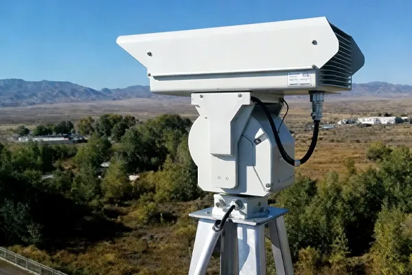
The solution integrates front-end thermal imaging warning equipment with a dedicated monitoring and management platform. Its structure combines long-distance thermal observation, visible-light verification, wireless transmission, intelligent software analysis, and centralized command support.
The system supports applications across multiple environments, including:
forest areas
grassland areas
dry vegetation or straw-burning risk zones
park and scenic areas
This means the project was not only built for one single point, but for broader ecological fire prevention scenarios where different terrain and risk conditions must be managed together.
Smarter Monitoring Across Large Areas
One of the most important values of this project is the shift from passive inspection to continuous intelligent monitoring.
Instead of depending only on field personnel to discover smoke or fire signs, the system helps maintain a persistent watch over key areas through thermal imaging and platform-based analysis. This is particularly important in mountainous regions where visual visibility, patrol efficiency, and response time can all be affected by terrain and distance.
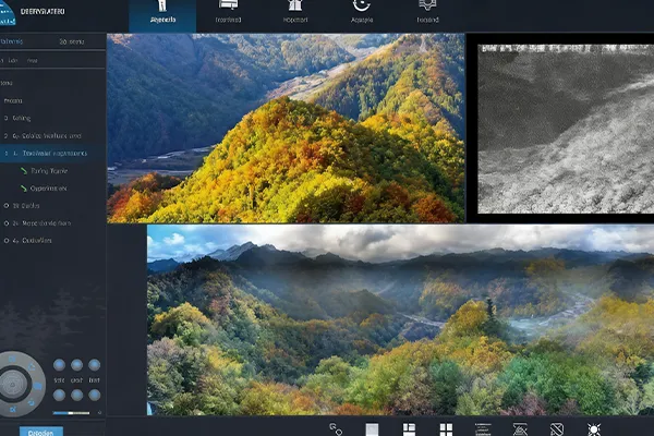
The platform functions also indicate that the project supports a more complete management model, including panoramic image stitching, meteorological management, resource management, virtual zone deployment, and interactive map-based fire point positioning. This gives forest protection teams more than a live image feed; it gives them a more usable operational view of the protected area.
From Detection to Decision Support
The project is valuable not only because it detects, but because it helps people act with more confidence.
The system also features intelligent analysis capability for identifying smoke, fire points, vehicles, personnel, and other monitored targets. In a forest fire prevention scenario, this kind of analysis can help reduce the time needed to distinguish between a real risk and background environmental interference.
The combination of monitoring images, target recognition, map-based visualization, and zone management supports faster verification and better coordination. In practical terms, this helps operators answer critical questions earlier:
Where is the possible fire point?
How large is the visible impact area?
What surrounding resources or risk zones are nearby?
How should personnel respond first?
That shift from image collection to decision support is what makes the project more than a hardware deployment.
Practical Value for Forest Protection
For the Helan Mountain project, the system created value in several practical ways.
It improved visibility over a wide and complex terrain area.
It strengthened early warning capability for smoke and fire risks.
It supported more centralized management through a dedicated software platform.
It helped combine monitoring, analysis, map positioning, and resource management into one operational process.
It provided a stronger technical foundation for long-term forest fire prevention work.
This kind of project is especially meaningful in areas where ecological protection, tourism activity, and fire prevention responsibility overlap. A delayed response in such areas can quickly increase operational pressure, while earlier warning creates more room for safer and more effective intervention.
Why This Case Matters
The Helan Mountain forest fire prevention project reflects an increasingly important direction in large-area ecological security: replacing fragmented monitoring methods with integrated, intelligent, and continuously operating systems.
Rather than relying only on patrol frequency or isolated camera points, the customer benefits from a solution that combines detection, visualization, management, and warning support in one platform-based structure.
For forestry bureaus, scenic areas, grassland management departments, and ecological protection authorities, this case shows how modern thermal imaging and intelligent monitoring technologies can support earlier discovery and better control in real outdoor fire prevention work.
Conclusion
The Helan Mountain forest fire prevention project demonstrates the practical value of intelligent early warning technology in large-scale ecological protection scenarios. By combining long-distance monitoring, intelligent analysis, platform management, and map-based warning support, the system helps improve both early fire discovery and overall forest protection efficiency.
For customers facing similar challenges in forests, grasslands, scenic zones, or remote ecological protection areas, this case provides a strong example of how integrated fire prevention monitoring can support safer and more proactive management.